Breeveld | |
|---|---|
Breeveld, by the Limesbrug in July 2012 | |
 | |
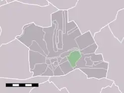 The statistical district of Breeveld in the municipality of Woerden. | |
| Coordinates: 52°5′50″N 4°54′40″E / 52.09722°N 4.91111°E | |
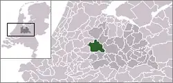
| Country | Netherlands |
| Province | Utrecht |
| Municipality | Woerden |
| Area | |
| • Total | 1.42 km2 (0.55 sq mi) |
| Population (2021)[1] | |
| • Total | 95 |
| • Density | 67/km2 (170/sq mi) |
| Time zone | UTC+1 (CET) |
| • Summer (DST) | UTC+2 (CEST) |
| Postal code | 3445[1] |
| Dialing code | 0348 |
Breeveld is a hamlet in the Dutch province of Utrecht. It is a part of the municipality of Woerden, and lies about 4 km northeast of the city centre.
The hamlet was first mentioned in 1217 as Bretevelt, and means "wide field".[2] Breeveld has no place name signs.[3]
Gallery
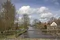 Breeveld (left) and Geestdorp (right) along the Oude Rijn
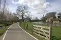 View on Breeveld
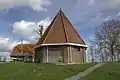 Pumping station
References
- 1 2 3 "Kerncijfers wijken en buurten 2021". Central Bureau of Statistics. Retrieved 26 March 2022.
- ↑ "Breeveld - (geografische naam)". Etymologiebank (in Dutch). Retrieved 26 March 2022.
- ↑ "Breeveld". Plaatsengids (in Dutch). Retrieved 26 March 2022.
Wikimedia Commons has media related to Breeveld.
This article is issued from Wikipedia. The text is licensed under Creative Commons - Attribution - Sharealike. Additional terms may apply for the media files.