| Burnhope Burn | |
|---|---|
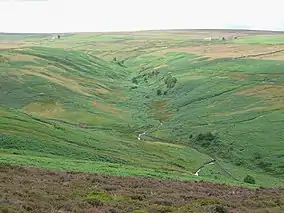 The valley of Burnhope Burn | |
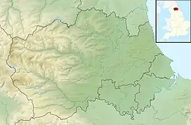 Location of Burnhope Burn SSSI, Co Durham | |
| Location | Wear Valley, North East, England |
| Coordinates | 54°51′6″N 1°57′20″W / 54.85167°N 1.95556°W |
| Area | 12.6 acres (5.1 ha) |
| Established | 1987 |
| Governing body | Natural England |
| Website | MAGiC MaP |
Burnhope Burn is a Site of Special Scientific Interest in the Wear Valley district of north County Durham, England.[1] It consists of a 12.6-acre (5.1 ha) area of woodland, carr, fen and mire in the valley of Burnhope Burn, just below the dam of the Derwent Reservoir, a mile (1.6 km) north-east of the village of Edmundbyers.
It contains a range of habitats that are characteristic of poorly drained soils and that are rare or local in County Durham; such as smooth-stalked sedge (Carex levigata), bogbean (Menyanthes) and globeflower (Trollius). In a small basin-mire in the northern part of the site, there are abundant communities of a number of species that have a localised distribution elsewhere in the county.[2]
References
- ↑ "Burnhope Burn SSSI". Natural England. Retrieved 21 January 2019.
- ↑ "Burnhope Burn" (PDF). Natural England. 1987. Retrieved 21 January 2019.
This article is issued from Wikipedia. The text is licensed under Creative Commons - Attribution - Sharealike. Additional terms may apply for the media files.