Cabrobó | |
|---|---|
Municipality | |
 Flag  Seal | |
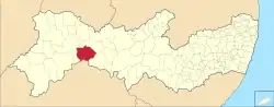 Location in Pernambuco | |
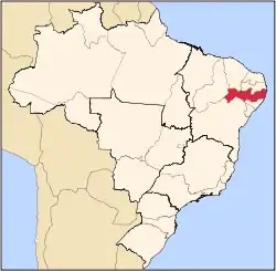
 Cabrobó Location in Brazil | |
| Coordinates: 08°30′51″S 38°16′36″W / 8.51417°S 38.27667°W | |
| Country | |
| Region | Southeast |
| State | Pernambuco |
| Mesoregion | São Francisco Pernambucano |
| Microregion | Petrolina |
| Incorporated (municipality) | September 11, 1928 |
| Government | |
| • Mayor | Marcilio Rodrigues Cavalcante |
| Area | |
| • Total | 1,657.706 km2 (640.044 sq mi) |
| Elevation | 325 m (1,066 ft) |
| Population (2020 [2]) | |
| • Total | 34,503 |
| • Density | 8.71/km2 (22.6/sq mi) |
| Demonym | Cabroboense[3] |
| Time zone | UTC−3 (BRT) |
| CEP postal code | 56180-000 |
| Area code | 87 |
| HDI (2010) [4] | 0.623 |
| Website | cabrobo.pe.gov.br |
Cabrobó is a city in the Brazilian state of Pernambuco, 536 km away from the state's capital, Recife. The city is located just to the north of a section of the São Francisco River that contains many archipelagos.
History
The Truká people had historically occupied the Ilha da Assunção archipelago of the São Francisco River in Cabrobó municipality.[5]
Ponti, an extinct Jê language belonging to the Jeicó group, was once spoken on an island in the São Francisco River near the city of Quebrobó (Cabrobó).[6]
Geography
- State - Pernambuco
- Region - Pernambucan San Francisco
- Boundaries - Terra Nova (N); Bahia state (S); Salgueiro and Belém de São Francisco (E); Orocó (W)
- Area - 1658.08 km²
- Elevation - 325 m
- Hydrography - Terra Nova River
- Vegetation - Caatinga hiperxerófila.
- Climate - Semi arid (Sertão) hot and dry
- Annual average temperature - 26.2 c
- Distance to Recife - 536 km
Economy
The main economic activities in Cabrobó are based in general commerce and agribusiness, especially farming of goats, sheep, cattle, pigs; and plantations of onions, cannabis, water melons and rice.
Economic Indicators
| Population | GDP x(1000 R$).[7] | GDP pc (R$) | PE |
|---|---|---|---|
| 30.432 | 122.201 | 4.236 | 0.20% |
Economy by Sector 2006
| Primary sector | Secondary sector | Service sector |
|---|---|---|
| 14.77% | 12.86% | 72.37% |
Health Indicators
| HDI (2000) | Hospitals (2007) | Hospitals beds (2007) | Children's Mortality every 1000 (2005) |
|---|---|---|---|
| 0.677 | 1 | 45 | 32.3 |
References
- ↑ "Área territorial oficial" [Official Territorial Area] (in Portuguese). Brazilian Institute of Geography and Statistics (IBGE). 2002-10-10. Retrieved 2018-01-26.
- ↑ IBGE 2020
- ↑ "IBGE - Cidades@". O Brasil Município por Município. Brazilian Institute of Geography and Statistics (IBGE). Retrieved 2018-01-26.
- ↑ "Ranking decrescente do IDH-M dos municípios do Brasil" [Ranking of HDI-M of Brazilian Municipalities] (PDF) (in Portuguese). United Nations Development Programme (UNDP). 2010. Retrieved 2013-08-03.
- ↑ "Truká". Povos Indígenas no Brasil (in Portuguese). Retrieved 29 January 2020.
- ↑ Loukotka, Čestmír (1968). Classification of South American Indian languages. Los Angeles: UCLA Latin American Center.
- ↑ Cabrobó 2007 GDP IBGE page 29 Archived March 4, 2016, at the Wayback Machine
- ↑ PE State site - City by city profile
Capital: Recife | ||||||||||||||
| Mesoregion Agreste Pernambucano |
|  | ||||||||||||
| Mesoregion Mata Pernambucana |
| |||||||||||||
| Mesoregion Metropolitana de Recife |
| |||||||||||||
| Mesoregion Sao Francisco Pernambucano |
| |||||||||||||
| Mesoregion Sertão Pernambucano |
| |||||||||||||
This article is issued from Wikipedia. The text is licensed under Creative Commons - Attribution - Sharealike. Additional terms may apply for the media files.