Cered | |
|---|---|
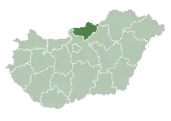
 Cered Location of Cered | |
| Coordinates: 48°08′44″N 19°57′56″E / 48.14545°N 19.96569°E | |
| Country | |
| County | Nógrád |
| Area | |
| • Total | 38.58 km2 (14.90 sq mi) |
| Population (2004) | |
| • Total | 1,214 |
| • Density | 31.46/km2 (81.5/sq mi) |
| Time zone | UTC+1 (CET) |
| • Summer (DST) | UTC+2 (CEST) |
| Postal code | 3123 |
| Area code | 32 |
Cered is a village in Nógrád county, Hungary.
| Year | Population |
|---|---|
| 1870 | 711 |
| 1880 | 726 |
| 1890 | 767 |
| 1900 | 1147 |
| 1910 | 1239 |
| 1920 | 1435 |
| 1930 | 1630 |
| 1941 | 1447 |
| 1949 | 1798 |
| 1960 | 1760 |
| 1970 | 1753 |
| 1980 | 1576 |
| 1990 | 1433 |
| 2001 | 1282 |
| 2011 | 1170 |
References
- ↑ "Nógrád county - Data on localities - Population number, population density". Hungarian Central Statistical Office/Központi Statisztikai Hivatal. Retrieved 2021-05-22.
External links
- Street map (in Hungarian)
This article is issued from Wikipedia. The text is licensed under Creative Commons - Attribution - Sharealike. Additional terms may apply for the media files.