Cetechovice | |
|---|---|
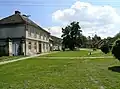 Centre of Cetechovice | |
 Flag  Coat of arms | |
 Cetechovice Location in the Czech Republic | |
| Coordinates: 49°10′20″N 17°15′41″E / 49.17222°N 17.26139°E | |
| Country | |
| Region | Zlín |
| District | Kroměříž |
| First mentioned | 1141 |
| Area | |
| • Total | 7.49 km2 (2.89 sq mi) |
| Elevation | 328 m (1,076 ft) |
| Population (2023-01-01)[1] | |
| • Total | 194 |
| • Density | 26/km2 (67/sq mi) |
| Time zone | UTC+1 (CET) |
| • Summer (DST) | UTC+2 (CEST) |
| Postal code | 767 02 |
| Website | www |
Cetechovice is a municipality and village in Kroměříž District in the Zlín Region of the Czech Republic. It has about 200 inhabitants.
Cetechovice lies approximately 16 kilometres (10 mi) south-west of Kroměříž, 30 km (19 mi) west of Zlín, and 229 km (142 mi) south-east of Prague.
Gallery
- Common
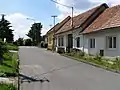 Side street
References
Wikimedia Commons has media related to Cetechovice.
This article is issued from Wikipedia. The text is licensed under Creative Commons - Attribution - Sharealike. Additional terms may apply for the media files.