Chapada da Natividade | |
|---|---|
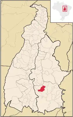 Location in Tocantins state | |
 Chapada da Natividade Location in Brazil | |
| Coordinates: 11°37′01″S 47°45′03″W / 11.61694°S 47.75083°W | |
| Country | Brazil |
| Region | North |
| State | Tocantins |
| Area | |
| • Total | 1,671 km2 (645 sq mi) |
| Population (2020 [1]) | |
| • Total | 3,331 |
| • Density | 2.0/km2 (5.2/sq mi) |
| Time zone | UTC−3 (BRT) |
Chapada da Natividade is a municipality located in the Brazilian state of Tocantins. Its population was 3,331 (2020) and its area is 1,671 km².[2]
References
- ↑ "IBGE 2020". Retrieved 26 January 2021.
- ↑ IBGE - "Archived copy". Archived from the original on 2008-06-11. Retrieved 2008-06-11.
{{cite web}}: CS1 maint: archived copy as title (link)
This article is issued from Wikipedia. The text is licensed under Creative Commons - Attribution - Sharealike. Additional terms may apply for the media files.