Chasong County
자성군 | |
|---|---|
| Korean transcription(s) | |
| • Hanja | 慈城郡 |
| • McCune-Reischauer | Chasŏng kun |
| • Revised Romanization | Jaseong-gun |
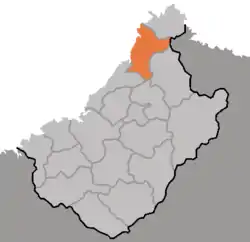 Map of Chagang showing the location of Chasong | |
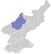
| Country | North Korea |
| Province | Chagang Province |
| Area | |
| • Total | 864 km2 (334 sq mi) |
| Population (2008[1]) | |
| • Total | 50,939 |
| • Density | 59/km2 (150/sq mi) |
Chasŏng County is a county (kun) in Chagang Province, North Korea. The city is immediately south of the Chinese-North Korean border. Its approximate population to 7 km from the city center is 8,317. The average altitude is 1279 feet, or 389 meters. Nearby cities and towns include Haengjangp'yong and Umnae-dong.
Administrative divisions
Chasŏng County is divided into 1 ŭp (town), 1 rodongjagu (workers' district) and 15 ri (villages):
|
|
Sources
External links
Wikimedia Commons has media related to Chasong.
- In Korean language online encyclopedias:
41°27′39″N 126°38′29″E / 41.4608°N 126.6414°E
This article is issued from Wikipedia. The text is licensed under Creative Commons - Attribution - Sharealike. Additional terms may apply for the media files.