Chiulikam, Arizona | |
|---|---|
Populated place | |
 Chiulikam  Chiulikam | |
| Coordinates: 32°34′28″N 112°31′34″W / 32.57444°N 112.52611°W | |
| Country | United States |
| State | Arizona |
| County | Maricopa |
| Elevation | 2,136 ft (651 m) |
| Time zone | UTC-7 (Mountain (MST)) |
| • Summer (DST) | UTC-7 (MST) |
| Area code | 520 |
| FIPS code | 04-12885 |
| GNIS feature ID | 24366 |
Chiulikam is a populated place situated in Maricopa County, Arizona, United States.[2] It has numerous other unofficial names by which it is known, which include: Chiuli, Salcilla, Sauceda Well, Suwuki Vaya, Tschiulikam, and Vokivaxia. It has an estimated elevation of 2,136 feet (651 m) above sea level.[1]
References
- 1 2 "Feature Detail Report for: Chiulikam". Geographic Names Information System. United States Geological Survey, United States Department of the Interior.
- ↑ "Chiulikam (in Maricopa County, AZ) Populated Place Profile". AZ Hometown Locator. Retrieved November 2, 2016.
Municipalities and communities of Maricopa County, Arizona, United States | ||
|---|---|---|
| Cities | 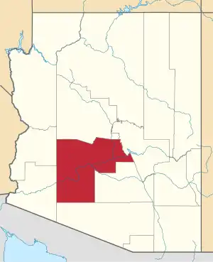 | |
| Towns | ||
| CDPs | ||
| Populated places |
| |
| Indian reservations | ||
| Ghost towns/ former populated places | ||
| Footnotes | ‡This populated place also has portions in an adjacent county or counties | |
This article is issued from Wikipedia. The text is licensed under Creative Commons - Attribution - Sharealike. Additional terms may apply for the media files.