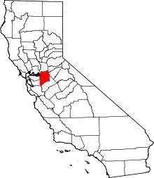
Clements, California | |
|---|---|
 Clements  Clements | |
| Coordinates: 38°11′27″N 121°05′18″W / 38.19083°N 121.08833°W | |
| Country | United States |
| State | California |
| County | San Joaquin |
| Elevation | 138 ft (42 m) |
| Population | |
| • Total | 857[1] |
| Time zone | UTC-8 (Pacific (PST)) |
| • Summer (DST) | UTC-7 (PDT) |
| ZIP code | 95227 |
| Area code | 209 |
| GNIS feature ID | 221206[2] |
Clements is an unincorporated community in San Joaquin County, California, United States. Clements is located on California State Route 12 and California State Route 88, 11 miles (18 km) east-northeast of Lodi. Clements has a post office with ZIP code 95227.[3]
History
Clements was laid out in about 1872.[4] The founder, Thomas Clements, gave the community his name.[5] A post office has been in operation at Clements since 1882.[6]
See also
References
- ↑ "People in Zip 95227 (Clements, CA)". Bestplaces.net. Retrieved September 7, 2022.
- ↑ U.S. Geological Survey Geographic Names Information System: Clements, California
- ↑ ZIP Code Lookup Archived 2011-06-14 at the Wayback Machine
- ↑ "Older towns dot valley when Lodi established". Lodi News-Sentinel. September 9, 1969. pp. 8C. Retrieved October 28, 2015.
- ↑ Durham, David L. (1998). California's Geographic Names: A Gazetteer of Historic and Modern Names of the State. Quill Driver Books. p. 759. ISBN 1-884995-14-4.
- ↑ "San Joaquin County". Jim Forte Postal History. Retrieved October 28, 2015.
This article is issued from Wikipedia. The text is licensed under Creative Commons - Attribution - Sharealike. Additional terms may apply for the media files.
