Coppens Corner, Wisconsin | |
|---|---|
 Coppens Corner  Coppens Corner | |
| Coordinates: 44°27′30″N 87°47′08″W / 44.45833°N 87.78556°W | |
| Country | |
| State | |
| County | Brown |
| Town | Eaton |
| Elevation | 274 m (899 ft) |
| Time zone | UTC-6 (Central (CST)) |
| • Summer (DST) | UTC-5 (CDT) |
| Area code | 920 |
| GNIS feature ID | 1577558[1] |
Coppens Corner is an unincorporated community in the Town of Eaton, Brown County, Wisconsin, United States.[1]
It is located at the corner of County Trunk JJ and County Trunk P.[2] The community was named for Phil and Catherine Coppens, who owned land in the area in the 1860s.[3]
Notes
- 1 2 "Coppens Corner, Wisconsin". Geographic Names Information System. United States Geological Survey, United States Department of the Interior.
- ↑ "Map of Coppens Corner". google-maps.pro. Retrieved October 19, 2016.
- ↑ Callary, Edward. Place Names of Wisconsin. Madison, WI: University of Wisconsin Press. p. 64. ISBN 978-0-299-30964-0.
Municipalities and communities of Brown County, Wisconsin, United States | ||
|---|---|---|
| Cities | 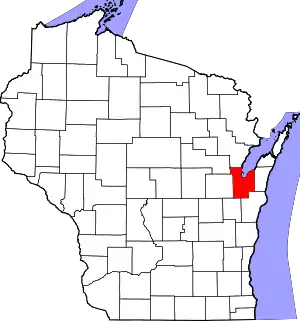 | |
| Villages | ||
| Towns | ||
| CDPs | ||
| Unincorporated communities |
| |
| Indian reservation | ||
| Ghost towns/ neighborhoods | ||
| Footnotes | ‡This populated place also has portions in an adjacent county or counties | |
This article is issued from Wikipedia. The text is licensed under Creative Commons - Attribution - Sharealike. Additional terms may apply for the media files.