 Shown within Romania | |
| Location | Vârful Pietrei,[1] Clopotiva, Hunedoara, Romania |
|---|---|
| Coordinates | 45°28′37″N 22°48′18″E / 45.477°N 22.805°E |
| Site notes | |
| Condition | Ruined |
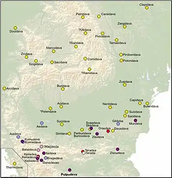
It was a Dacian fortified town.
References
- ↑ "National Archaeological Record (RAN)". ran.cimec.ro. Archived from the original on 19 September 2012. Retrieved 11 November 2012.
| Tribes (List) | |||||||||||||||||
|---|---|---|---|---|---|---|---|---|---|---|---|---|---|---|---|---|---|
| Kings |
| ||||||||||||||||
| |||||||||||||||||
Wars with the Roman Empire |
| ||||||||||||||||
| Roman Dacia / Free Dacians |
| ||||||||||||||||
| Research |
| ||||||||||||||||
| |||||||||||||||||
This article is issued from Wikipedia. The text is licensed under Creative Commons - Attribution - Sharealike. Additional terms may apply for the media files.