Division No. 2 | |
|---|---|
| Country | Canada |
| Province | Alberta |
| Area | |
| • Total | 17,662 km2 (6,819 sq mi) |
| As of 2011 | |
| Population (2011)[1] | |
| • Total | 156,536 |
| • Density | 8.9/km2 (23/sq mi) |
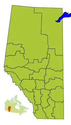
Division No. 2 is a census division in Alberta, Canada. It is located in the south-central portion of southern Alberta and includes the City of Lethbridge.
Census subdivisions
The following census subdivisions (municipalities or municipal equivalents) are located within Alberta's Division No. 2.[2][3]
- Cities
- Towns
- Villages
- Hamlets
- Municipal districts
Demographics
In the 2021 Census of Population conducted by Statistics Canada, Division No. 2 had a population of 178,513 living in 66,523 of its 70,936 total private dwellings, a change of 5.2% from its 2016 population of 169,729. With a land area of 17,456.33 km2 (6,739.93 sq mi), it had a population density of 10.2/km2 (26.5/sq mi) in 2021.[4]
See also
References
- 1 2 "Population and dwelling counts, for Canada, provinces and territories, and census divisions, 2011 and 2006 censuses (Alberta)". Statistics Canada. February 8, 2012. Retrieved February 16, 2012.
- ↑ "2006 Community Profiles, Geographic hierarchy – Division No. 2 (Census division)". Statistics Canada. December 7, 2010. Retrieved August 30, 2011.
- ↑ "2022 Municipal Codes" (PDF). Alberta Municipal Affairs. January 5, 2022. Retrieved January 21, 2022.
- ↑ "Population and dwelling counts: Canada and census divisions". Statistics Canada. February 9, 2022. Retrieved April 2, 2022.
Places adjacent to Division No. 2, Alberta | ||||||||||||||||
|---|---|---|---|---|---|---|---|---|---|---|---|---|---|---|---|---|
| ||||||||||||||||


Subdivisions of Alberta | |
|---|---|
| Subdivisions | |
| Communities | |
| Cities and urban service areas | |
| Census divisions | |
| |

.svg.png.webp)

This article is issued from Wikipedia. The text is licensed under Creative Commons - Attribution - Sharealike. Additional terms may apply for the media files.