Dunluce Lower
| |
|---|---|
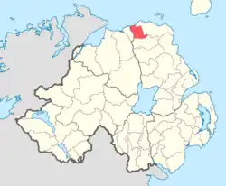 Location of DunluceLower, County Antrim, Northern Ireland | |
| Sovereign state | United Kingdom |
| Country | Northern Ireland |
| County | Antrim |
Dunluce Lower is a barony in County Antrim, Northern Ireland.[2] To its north runs the north-Antrim coast, and it is bordered by three other baronies: Dunluce Upper to the south, Cary to the east, and the North East Liberties of Coleraine to the west.[2] The River Bush flows through this barony.[1] Dunluce Lower also formed the northern part of the medieval territory known as the Route.[3]
History
List of main settlements
Below is a list of settlements in Dunluce Lower:[1]
Towns
Villages
Population centres
- Priestland
List of civil parishes
Below is a list of civil parishes in Dunluce Lower:[4][5]
- Ballyrashane (also partly in barony of North-East Liberties of Coleraine)
- Ballywillan (split with barony of North-East Liberties of Coleraine)
- Billy (split with barony of Cary)
- Derrykeighan
- Dunluce
References
- 1 2 3 "Dunluce Lower". Placenames Database of Ireland. Department of Community, Rural and Gaeltacht Affairs. Retrieved 5 June 2011.
- 1 2 "Public Record Office of Northern Ireland (PRONI) – nidirect". proni.gov.uk. 4 March 2016. Retrieved 17 April 2018.
- ↑ Ulster Archaeological Society. "Ulster journal of archaeology". Belfast [Ulster Archaeological Society]. Retrieved 17 April 2018 – via Internet Archive.
- ↑ "Unavailable". applications.proni.gov.uk. Archived from the original on 27 July 2011. Retrieved 17 April 2018.
- ↑ "Unavailable". applications.proni.gov.uk. Archived from the original on 27 July 2011. Retrieved 17 April 2018.


This article is issued from Wikipedia. The text is licensed under Creative Commons - Attribution - Sharealike. Additional terms may apply for the media files.