Dvakačovice | |
|---|---|
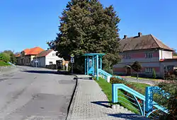 Main road in the centre of Dvakačovice | |
 Flag  Coat of arms | |
 Dvakačovice Location in the Czech Republic | |
| Coordinates: 49°58′44″N 15°53′40″E / 49.97889°N 15.89444°E | |
| Country | |
| Region | Pardubice |
| District | Chrudim |
| First mentioned | 1415 |
| Area | |
| • Total | 3.63 km2 (1.40 sq mi) |
| Elevation | 248 m (814 ft) |
| Population (2023-01-01)[1] | |
| • Total | 195 |
| • Density | 54/km2 (140/sq mi) |
| Time zone | UTC+1 (CET) |
| • Summer (DST) | UTC+2 (CEST) |
| Postal code | 538 62 |
| Website | www |
Dvakačovice is a municipality and village in Chrudim District in the Pardubice Region of the Czech Republic. It has about 200 inhabitants.
Gallery
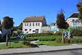 Centre of Dvakačovice
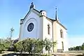 Evangelical church
 Municipal office
References
External links
Wikimedia Commons has media related to Dvakačovice.
This article is issued from Wikipedia. The text is licensed under Creative Commons - Attribution - Sharealike. Additional terms may apply for the media files.