| East Mount Lowther | |
|---|---|
 | |
| Highest point | |
| Elevation | 631 m (2,070 ft)[1] |
| Prominence | 75 m (246 ft)[1] |
| Listing | Tu,Sim,D,GT,DN[2] |
| Geography | |
| Location | Dumfries and Galloway, Scotland |
| Parent range | Lowther Hills, Southern Uplands |
| OS grid | NS 87857 09989 |
| Topo map | OS Landranger 71, 78 |
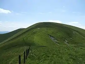
East Mount Lowther is a hill in the Lowther Hills range, part of the Southern Uplands of Scotland. The hill is most often climbed as a detour before or after ascending Lowther Hill, however much longer approaches from the south utilising ancient pathways such as the medieval Enterkin Pass are also possible - a viewpoint indicator is located at the summit.[1][3]
References
- 1 2 3 "East Mount Lowther". www.hill-bagging.co.uk.
- ↑ "Database of British and Irish Hills: user guide". www.hills-database.co.uk.
- ↑ "Heritage Paths - Search for Paths by Map". www.heritagepaths.co.uk.
This article is issued from Wikipedia. The text is licensed under Creative Commons - Attribution - Sharealike. Additional terms may apply for the media files.