Elgersburg | |
|---|---|
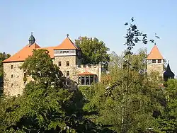 Elgersburg Castle | |
 Coat of arms | |
Location of Elgersburg within Ilm-Kreis district 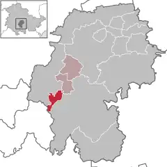 | |
 Elgersburg 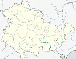 Elgersburg | |
| Coordinates: 50°42′16″N 10°51′13″E / 50.70444°N 10.85361°E | |
| Country | Germany |
| State | Thuringia |
| District | Ilm-Kreis |
| Municipal assoc. | Geratal/Plaue |
| Government | |
| • Mayor (2022–28) | Mario Augner[1] |
| Area | |
| • Total | 9.49 km2 (3.66 sq mi) |
| Elevation | 490 m (1,610 ft) |
| Population (2022-12-31)[2] | |
| • Total | 1,221 |
| • Density | 130/km2 (330/sq mi) |
| Time zone | UTC+01:00 (CET) |
| • Summer (DST) | UTC+02:00 (CEST) |
| Postal codes | 98716 |
| Dialling codes | 03677 |
| Vehicle registration | IK |
| Website | www.elgersburg.com |
Elgersburg is a municipality situated in the district of Ilm-Kreis, Thuringia, Germany.
The Elgersburg Castle
References
- ↑ Gewählte Bürgermeister - aktuelle Landesübersicht, Freistaat Thüringen, accessed 10 November 2022.
- ↑ "Bevölkerung der Gemeinden, erfüllenden Gemeinden und Verwaltungsgemeinschaften in Thüringen Gebietsstand: 31.12.2022" (in German). Thüringer Landesamt für Statistik. June 2023.
Towns and municipalities in Ilm-Kreis | ||
|---|---|---|
Coat of arms | ||
This article is issued from Wikipedia. The text is licensed under Creative Commons - Attribution - Sharealike. Additional terms may apply for the media files.