| Erlauf | |
|---|---|
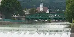 The Erlauf at Scheibbs | |
| Location | |
| Country | Austria |
| States | Lower Austria and Styria |
| Physical characteristics | |
| Source | |
| • location | at the foot of the Gemeindealpe |
| • coordinates | 47°48′27″N 15°13′48″E / 47.8076°N 15.2299°E |
| Mouth | |
• location | at Pöchlarn into the Danube |
• coordinates | 48°12′48″N 15°11′39″E / 48.2134°N 15.1943°E |
| Basin size | 632 km2 (244 sq mi) |
| Basin features | |
| Progression | Danube→ Black Sea |
Erlauf is a river of Lower Austria and of Styria, Austria.[1] Its drainage basin is 632 km2 (244 sq mi).[2]
The Erlauf springs at the foot of the mountain Gemeindealpe[1][3] It is a right tributary of the Danube in Pöchlarn.[4]
References
Wikimedia Commons has media related to Erlauf (river).
- 1 2 "Erlauf source and Gemeindealpe". Niederösterreich ATLAS. Retrieved 22 January 2020. (look for Erlaufursprung)
- ↑ "Flächenverzeichnis der Flussgebiete: Donaugebiet von der Enns bis zur Leitha" (PDF). Beiträge zur Hydrografie Österreichs Heft 62. December 2014. p. 49.
- ↑ Google (20 January 2020). "Erlach source" (Map). Google Maps. Google. Retrieved 20 January 2020.
- ↑ Google (20 January 2020). "Erlauf mouth" (Map). Google Maps. Google. Retrieved 20 January 2020.
This article is issued from Wikipedia. The text is licensed under Creative Commons - Attribution - Sharealike. Additional terms may apply for the media files.