Eurymedon Bridge (Selge) | |
|---|---|
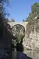
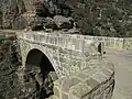
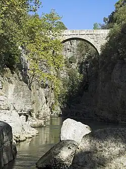 The Roman bridge over the Eurymedon valley | |
| Coordinates | 37°11′31″N 31°10′52″E / 37.191973°N 31.181033°E |
| Crosses | Eurymedon (Köprüçay) |
| Locale | Near Selge, Pisidia, Turkey |
| Official name | Oluk Köprü |
| Characteristics | |
| Design | Arch bridge |
| Material | Stone |
| Total length | 14 m |
| Width | 3.5 m |
| Longest span | 7 m |
| History | |
| Construction end | 2nd century AD |
| Location | |
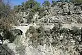
The Eurymedon Bridge (Turkish: Oluk Köprü) is a Roman bridge over the river Eurymedon (modern Köprüçay River) near Selge in Pisidia in southern Turkey.[1] It is part of the road winding up from the coastal region Pamphylia to the Pisidian hinterland.[1] Located 5 km north of the village Beşkonak in a sparsely settled area, the bridge crosses the Eurymedon high above the valley bottom.[1]
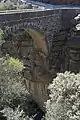
The excellently preserved structure is 14 m long and 3.5 m wide (with a roadway of 2.5 m).[1] The clear span of its single arch is c. 7 m, the thickness of its voussoirs, which were set without the use of mortar, 60 cm.[1] The building technique and the sturdy stonework point to a construction date in the 2nd century AD, a time when Selge was flourishing.[2]
Forty-two km downstream at Aspendos, the Eurymedon is crossed by another extant old bridge.[3]
Gallery

See also
References
- 1 2 3 4 5 Galliazzo 1994, p. 409
- ↑ Galliazzo 1994, p. 410
- ↑ O’Connor 1993, p. 126
Sources
- Bean, George E. (1968), Turkey's Southern Shore. An Archaeological Guide, London, p. 139
{{citation}}: CS1 maint: location missing publisher (link) - Galliazzo, Vittorio (1994), I ponti romani. Catalogo generale, vol. 2, Treviso: Edizioni Canova, pp. 409–410 (No. 856), ISBN 88-85066-66-6
- O’Connor, Colin (1993), Roman Bridges, Cambridge University Press, p. 126 (E25), ISBN 0-521-39326-4
External links
![]() Media related to Eurymedon Bridge (Selge) at Wikimedia Commons
Media related to Eurymedon Bridge (Selge) at Wikimedia Commons