Fonfría | |
|---|---|
 Fonfría | |
| Coordinates: 40°59′N 1°5′W / 40.983°N 1.083°W | |
| Country | Spain |
| Autonomous community | Aragon |
| Province | Teruel |
| Comarca | Jiloca |
| Area | |
| • Total | 20.35 km2 (7.86 sq mi) |
| Elevation | 1,247 m (4,091 ft) |
| Population (2018)[1] | |
| • Total | 28 |
| Time zone | UTC+1 (CET) |
| • Summer (DST) | UTC+2 (CEST) |
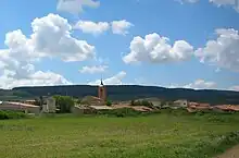
View of Fonfría with the Sierra de Cucalón in the background
Fonfría (Spanish pronunciation: [foɱ.ˈfɾi.a]) is a municipality located in the Jiloca Comarca, province of Teruel, Aragon, Spain. According to the 2010 census[2] the municipality has a population of 30 inhabitants.
Fonfría is located in the Sierra de Cucalón area, close to the sources of the Huerva River.
See also
References
- ↑ Municipal Register of Spain 2018. National Statistics Institute.
- ↑ Instituto Nacional de Estadística (Spain)
Wikimedia Commons has media related to Fonfría, Aragon.
This article is issued from Wikipedia. The text is licensed under Creative Commons - Attribution - Sharealike. Additional terms may apply for the media files.