Fuenferrada | |
|---|---|
 | |
 Fuenferrada Location in Spain | |
| Coordinates: 40°52′9.70″N 1°0′40.21″W / 40.8693611°N 1.0111694°W | |
| Country | |
| Autonomous community | |
| Province | Teruel |
| Comarca | Cuencas Mineras |
| Judicial district | Calamocha |
| Government | |
| • Alcalde | María Ortega Lacasa (PP) |
| Area | |
| • Total | 24.22 km2 (9.35 sq mi) |
| Elevation | 1,128 m (3,701 ft) |
| Population (2018)[1] | |
| • Total | 42 |
| • Density | 1.7/km2 (4.5/sq mi) |
| Demonym(s) | fonferrino, -a fuenferradino, -a |
| Time zone | UTC+1 (CET) |
| • Summer (DST) | UTC+2 (CEST) |
| Postal code | 44741 |
| Dialing code | (+34) 978 752... |
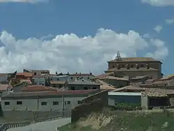
Fuenferrada is a town and municipality in Aragon, located in the comarca of Cuencas Mineras, in the province of Teruel. According to the 2005 census (INE), the municipality has a population of 43 inhabitants, with an area of 24.22 km2 and a density of 1.77.
The municipality is 73 kilometres from Teruel, the provincial capital.
References
- ↑ Municipal Register of Spain 2018. National Statistics Institute.
This article is issued from Wikipedia. The text is licensed under Creative Commons - Attribution - Sharealike. Additional terms may apply for the media files.