Galloway[1] is a neighborhood of southeast Springfield, Missouri, United States.[2] Galloway is located in a stream valley approximately one-half mile north of the U.S. Route 60 and U.S. Route 65 interchange and one mile south of Sequiota Park.[3]
History
A post office called Galloway was established in 1883, and remained in operation until 1943.[4] The community has the name of a Union Army officer.[5]
From 1945 and into the 1950s, the combined U.S. 60 - U.S. 65 highways passed through Galloway at the southeast entrance to Springfield.[6]
References
- ↑ U.S. Geological Survey Geographic Names Information System: Galloway, Springfield, Missouri
- ↑ Reports of the Public Service Commission of the State of Missouri. The Commission. 1970. p. 407.
formerly the old town of Galloway but by reason of annexation is now a part of Springfield, Missouri.
- ↑ Missouri Atlas & Gazetteer, DeLorme, 1998, First edition, p. 52, ISBN 0-89933-224-2
- ↑ "Post Offices". Jim Forte Postal History. Archived from the original on 3 October 2016. Retrieved 3 October 2016.
- ↑ "Greene County Place Names, 1928–1945 (archived)". The State Historical Society of Missouri. Archived from the original on 24 June 2016. Retrieved 3 October 2016.
{{cite web}}: CS1 maint: bot: original URL status unknown (link) - ↑ Ozark, Missouri, 15 Minute Topographic Quadrangle, USGS, 1945
Municipalities and communities of Greene County, Missouri, United States | ||
|---|---|---|
| Cities | 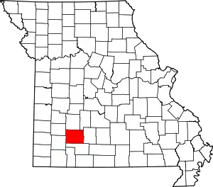 Map of Missouri highlighting Greene County | |
| Townships |
| |
| Unincorporated communities | ||
| Former settlement | ||
| Footnotes | ‡This populated place also has portions in an adjacent county or counties | |
37°08′12″N 93°14′17″W / 37.13667°N 93.23806°W
This article is issued from Wikipedia. The text is licensed under Creative Commons - Attribution - Sharealike. Additional terms may apply for the media files.