| Greyrock Mountain Trail | |
|---|---|
 Greyrock Mountain Trail | |
| Length | 3.1 miles (5.0 km)[1] |
| Location | Roosevelt National Forest, Colorado, United States |
| Designation | National Recreation Trail |
| Use | Hiking |
| Elevation change | 2,039 feet (621 m)[1] |
| Highest point | Greyrock Mountain summit 7,613 feet (2,320 m)[1] |
| Lowest point | Trailhead on Cache La Poudre river 5,574 feet (1,699 m)[1] |
| Difficulty | Moderate |
Greyrock Mountain National Recreation Trail is a hiking trail in Roosevelt National Forest west of Laporte, Colorado. The trail was constructed by the Civilian Conservation Corps in the 1930s[1] and designated as a National Recreation Trail in 1979.[2]
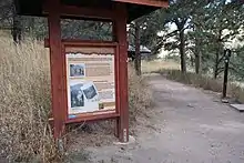
Sign at the trailhead informs hikers of the trail's history
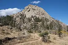
The National Recreation Trail approaching Greyrock Mountain
References
- 1 2 3 4 5 "Greyrock Trail #946". Poudre Wilderness Volunteers. Archived from the original on 2013-01-31. Retrieved 2011-01-20.
- ↑ "Greyrock Mountain Trail". National Recreation Trails Database.
This article is issued from Wikipedia. The text is licensed under Creative Commons - Attribution - Sharealike. Additional terms may apply for the media files.