Guaranda, Sucre | |
|---|---|
Municipality and town | |
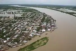 View of Guaranda | |
.svg.png.webp) Flag  Seal | |
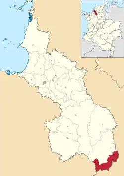 Location of the municipality and town of Guaranda, Sucre in the Sucre Department of Colombia. | |
| Country | |
| Department | Sucre Department |
| Area | |
| • Total | 354 km2 (137 sq mi) |
| Population (Census 2018[1]) | |
| • Total | 15,618 |
| • Density | 44/km2 (110/sq mi) |
| Time zone | UTC-5 (Colombia Standard Time) |
Guaranda is a town and municipality located in the Sucre Department, northern Colombia.
Climate
Guaranda has a tropical monsoon climate (Am) with heavy rainfall in all months except January.
| Climate data for Guaranda | |||||||||||||
|---|---|---|---|---|---|---|---|---|---|---|---|---|---|
| Month | Jan | Feb | Mar | Apr | May | Jun | Jul | Aug | Sep | Oct | Nov | Dec | Year |
| Mean daily maximum °C (°F) | 32.5 (90.5) |
33.2 (91.8) |
33.3 (91.9) |
33.1 (91.6) |
32.1 (89.8) |
32.0 (89.6) |
32.2 (90.0) |
32.0 (89.6) |
31.7 (89.1) |
31.4 (88.5) |
31.6 (88.9) |
32.0 (89.6) |
32.3 (90.1) |
| Daily mean °C (°F) | 27.7 (81.9) |
28.1 (82.6) |
28.5 (83.3) |
28.5 (83.3) |
27.8 (82.0) |
27.9 (82.2) |
27.7 (81.9) |
27.7 (81.9) |
27.3 (81.1) |
27.2 (81.0) |
27.6 (81.7) |
27.6 (81.7) |
27.8 (82.1) |
| Mean daily minimum °C (°F) | 23.0 (73.4) |
23.1 (73.6) |
23.7 (74.7) |
23.9 (75.0) |
23.6 (74.5) |
23.8 (74.8) |
23.2 (73.8) |
23.4 (74.1) |
23.0 (73.4) |
23.1 (73.6) |
23.6 (74.5) |
23.3 (73.9) |
23.4 (74.1) |
| Average rainfall mm (inches) | 0.8 (0.03) |
70.8 (2.79) |
100.5 (3.96) |
230.2 (9.06) |
444.6 (17.50) |
446.7 (17.59) |
482.8 (19.01) |
439.3 (17.30) |
374.7 (14.75) |
440.9 (17.36) |
295.6 (11.64) |
159.7 (6.29) |
3,486.6 (137.28) |
| Average rainy days | 2 | 3 | 3 | 8 | 12 | 12 | 13 | 14 | 12 | 13 | 11 | 6 | 109 |
| Source: [2] | |||||||||||||
References
- (in Spanish) Gobernacion de Sucre - Guaranda
- (in Spanish) Guaranda official website Archived 2021-01-19 at the Wayback Machine
- ↑ "Censo Nacional de Población y Vivienda 2018" (in Spanish). DANE. Archived from the original on 13 August 2020. Retrieved 25 April 2020.
- ↑ http://www.ideam.gov.co/documents/21021/553571/Promedios+Climatol%C3%B3gicos++1981+-+2010.xlsx/f28d0b07-1208-4a46-8ccf-bddd70fb4128
Municipalities in Sucre Department | ||
|---|---|---|
8°28′N 75°32′W / 8.467°N 75.533°W
This article is issued from Wikipedia. The text is licensed under Creative Commons - Attribution - Sharealike. Additional terms may apply for the media files.