| Guye | |
|---|---|
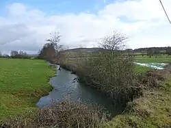 The Guye River in Savianges | |
  | |
| Location | |
| Country | France |
| Physical characteristics | |
| Source | |
| • location | Sainte-Hélène |
| • coordinates | 46°46′4.80″N 04°38′45.60″E / 46.7680000°N 4.6460000°E |
| Mouth | |
• location | Grosne |
• coordinates | 46°34′9.99″N 04°39′40.90″E / 46.5694417°N 4.6613611°E |
| Length | 46.6 km (29.0 mi) |
| Basin size | 430.00 km2 (166.02 sq mi) |
| Basin features | |
| Progression | Grosne→ Saône→ Rhône→ Mediterranean Sea |
The Guye (French pronunciation: [ɡi]) is a 46.6-kilometre (29.0 mi) long river in the Saône-et-Loire département, central eastern France. It flows primarily south, before turning east-northeast near Salornay-sur-Guye and flowing into the Grosne. It is a left tributary of the Grosne into which it flows between Malay and Savigny-sur-Grosne.[1]
Communes along its course
The following communes, ordered from source to mouth, lie along the Guye:
- Sainte-Hélène
- Moroges
- Bissey-sous-Cruchaud
- Sassangy
- Cersot
- Savianges
- Germagny
- Saint-Martin-du-Tartre
- Genouilly
- Joncy
- Burzy
- Saint-Martin-la-Patrouille
- Saint-Huruge
- Sailly
- Sigy-le-Châtel
- Salornay-sur-Guye
- Cortevaix
- Bonnay
- Malay
- Savigny-sur-Grosne[1]
Wikimedia Commons has media related to Guye (rivière).
References
This article is issued from Wikipedia. The text is licensed under Creative Commons - Attribution - Sharealike. Additional terms may apply for the media files.