Haslau-Maria Ellend | |
|---|---|
 Coat of arms | |
 Haslau-Maria Ellend Location within Austria | |
| Coordinates: 48°6′N 16°41′E / 48.100°N 16.683°E | |
| Country | Austria |
| State | Lower Austria |
| District | Bruck an der Leitha |
| Government | |
| • Mayor | Helmut Fritz |
| Area | |
| • Total | 24.84 km2 (9.59 sq mi) |
| Elevation | 186 m (610 ft) |
| Population (2018-01-01)[2] | |
| • Total | 2,004 |
| • Density | 81/km2 (210/sq mi) |
| Time zone | UTC+1 (CET) |
| • Summer (DST) | UTC+2 (CEST) |
| Postal code | 2402 |
| Area code | 02232 |
| Website | www.haslau-mariaellend.at |
Haslau-Maria Ellend is a municipality in the district of Bruck an der Leitha in Lower Austria in Austria.
Geography
Haslau-Maria Ellend lies in the industrial area of Lower Austria. About 42 percent of the municipality is forested.
References
- ↑ "Dauersiedlungsraum der Gemeinden Politischen Bezirke und Bundesländer - Gebietsstand 1.1.2018". Statistics Austria. Retrieved 10 March 2019.
- ↑ "Einwohnerzahl 1.1.2018 nach Gemeinden mit Status, Gebietsstand 1.1.2018". Statistics Austria. Retrieved 9 March 2019.
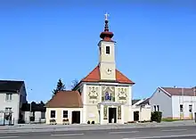
Parish church at Maria Ellend
This article is issued from Wikipedia. The text is licensed under Creative Commons - Attribution - Sharealike. Additional terms may apply for the media files.