Heidesee | |
|---|---|
.png.webp) Coat of arms | |
Location of Heidesee within Dahme-Spreewald district 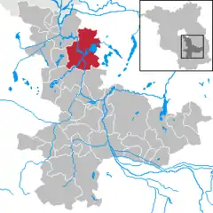 | |
 Heidesee  Heidesee | |
| Coordinates: 52°16′59″N 13°48′00″E / 52.28306°N 13.80000°E | |
| Country | Germany |
| State | Brandenburg |
| District | Dahme-Spreewald |
| Subdivisions | 11 Ortsteile |
| Government | |
| • Mayor (2019–27) | Björn Langner[1] |
| Area | |
| • Total | 134.78 km2 (52.04 sq mi) |
| Elevation | 35 m (115 ft) |
| Population (2021-12-31)[2] | |
| • Total | 7,120 |
| • Density | 53/km2 (140/sq mi) |
| Time zone | UTC+01:00 (CET) |
| • Summer (DST) | UTC+02:00 (CEST) |
| Postal codes | 15752, 15754 |
| Dialling codes | 033763, 033767 ,033768 |
| Vehicle registration | LDS |
| Website | www.heidesee-online.de |
Heidesee is a municipality in the district of Dahme-Spreewald in Brandenburg, which is located in the eastern part of Germany.
Demography
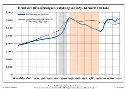 Development of Population since 1875 within the Current Boundaries (Blue Line: Population; Dotted Line: Comparison to Population Development of Brandenburg state; Grey Background: Time of Nazi rule; Red Background: Time of Communist rule)
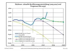 Recent Population Development and Projections (Population Development before Census 2011 (blue line); Recent Population Development according to the Census in Germany in 2011 (blue bordered line); Official projections for 2005-2030 (yellow line); for 2020-2030 (green line); for 2017-2030 (scarlet line)
|
|
|
Organization
Neighbourhoods
Heidesee consists of 11 villages, which were united to one town in 2003. These villages are:
- Bindow
- Blossin
- Dannenreich
- Dolgenbrodt
- Friedersdorf
- Gräbendorf
- Gussow
- Kolberg
- Prieros
- Streganz
- Wolzig
Coat of arms
The coat of arms of the village Gräbendorf is used for entire town, since the unification in 2003. It shows an egret beside a leaf of an oak.
Culture and sights
Sights
- Heimathaus Prieros (small museum)
- church Prieros
- church Gräbendorf
- landing stage / harbour Heidesee
- Haus des Waldes (house of forest) Gräbendorf
Nature
- Wolziger See
- natural park Dahme-Heideseen
- landscape conservation area Dubrow
References
- ↑ Landkreis Dahme-Spreewald Wahl der Bürgermeisterin / des Bürgermeisters, accessed 30 June 2021.
- ↑ "Bevölkerungsentwicklung und Flächen der kreisfreien Städte, Landkreise und Gemeinden im Land Brandenburg 2021" (PDF). Amt für Statistik Berlin-Brandenburg (in German). June 2022.
- ↑ Detailed data sources are to be found in the Wikimedia Commons.Population Projection Brandenburg at Wikimedia Commons
This article is issued from Wikipedia. The text is licensed under Creative Commons - Attribution - Sharealike. Additional terms may apply for the media files.