Helemano, Hawaii | |
|---|---|
 Helemano | |
| Coordinates: 21°32′9″N 158°1′11″W / 21.53583°N 158.01972°W | |
| Country | |
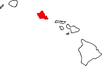
| State | Hawaii |
| County | Honolulu |
| Area | |
| • Total | 0.47 sq mi (1.20 km2) |
| • Land | 0.47 sq mi (1.20 km2) |
| • Water | 0.00 sq mi (0.00 km2) |
| Elevation | 1,099 ft (335 m) |
| Population (2020) | |
| • Total | 2,549 |
| • Density | 5,481.72/sq mi (2,116.04/km2) |
| Time zone | UTC-10 (Hawaii–Aleutian Time Zone) |
| ZIP Code | 96786 (Wahiawa) |
| Area code | 808 |
| FIPS code | 15-13970 |
| GNIS feature ID | 2804359[2] |
Helemano is a census-designated place (CDP) in Honolulu County, Hawaii, United States. It is north of the center of the island of Oahu, 9 miles (14 km) southeast of Waialua and 25 miles (40 km) northwest of Honolulu.
The community was first listed as a CDP prior to the 2020 census.
Demographics
| Census | Pop. | Note | %± |
|---|---|---|---|
| 2020 | 2,549 | — | |
| U.S. Decennial Census[3] | |||
References
- ↑ "2020 U.S. Gazetteer Files". United States Census Bureau. Retrieved December 18, 2021.
- 1 2 "Helemano Census Designated Place". Geographic Names Information System. United States Geological Survey, United States Department of the Interior.
- ↑ "Census of Population and Housing". Census.gov. Retrieved June 4, 2016.
Islands, municipalities, and communities of Honolulu County, Hawaii, United States | |||||
|---|---|---|---|---|---|
| CDPs |
|  Map of Hawaii highlighting Honolulu County | |||
| Other communities | |||||
| Government |
| ||||
This article is issued from Wikipedia. The text is licensed under Creative Commons - Attribution - Sharealike. Additional terms may apply for the media files.