Herresbach | |
|---|---|
 Coat of arms | |
Location of Herresbach within Mayen-Koblenz district 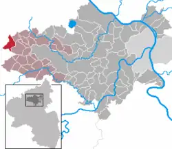 | |
 Herresbach  Herresbach | |
| Coordinates: 50°21′32″N 7°1′13″E / 50.35889°N 7.02028°E | |
| Country | Germany |
| State | Rhineland-Palatinate |
| District | Mayen-Koblenz |
| Municipal assoc. | Vordereifel |
| Government | |
| • Mayor (2019–24) | Achim Bürger[1] |
| Area | |
| • Total | 8.47 km2 (3.27 sq mi) |
| Elevation | 486 m (1,594 ft) |
| Population (2021-12-31)[2] | |
| • Total | 502 |
| • Density | 59/km2 (150/sq mi) |
| Time zone | UTC+01:00 (CET) |
| • Summer (DST) | UTC+02:00 (CEST) |
| Postal codes | 56729 |
| Dialling codes | 02691, 02656 |
| Vehicle registration | MYK |
| Website | www.herresbach-eifel.de |
Herresbach is a municipality in the district of Mayen-Koblenz, Rhineland-Palatinate, Germany.
References
- ↑ Direktwahlen 2019, Landkreis Mayen-Koblenz, Landeswahlleiter Rheinland-Pfalz, accessed 5 August 2021.
- ↑ "Bevölkerungsstand 2021, Kreise, Gemeinden, Verbandsgemeinden" (in German). Statistisches Landesamt Rheinland-Pfalz. 2022.
External links
- Herresbach (in German)
This article is issued from Wikipedia. The text is licensed under Creative Commons - Attribution - Sharealike. Additional terms may apply for the media files.