| Hesket Victoria | |||||||||||||||
|---|---|---|---|---|---|---|---|---|---|---|---|---|---|---|---|
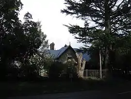 Hesket Primary School | |||||||||||||||
 Hesket | |||||||||||||||
| Coordinates | 37°21′S 144°37′E / 37.350°S 144.617°E | ||||||||||||||
| Population | 178 (SAL 2021)[1] | ||||||||||||||
| Postcode(s) | 3442 | ||||||||||||||
| Elevation | 650 m (2,133 ft) | ||||||||||||||
| Location | |||||||||||||||
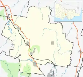
| LGA(s) | Shire of Macedon Ranges | ||||||||||||||
| State electorate(s) | Macedon | ||||||||||||||
| Federal division(s) | McEwen | ||||||||||||||
| |||||||||||||||
Hesket is a locality in the Macedon Ranges Shire, in Victoria, Australia on the northern side of the Mount Macedon Range. The settlement was originally known as Ferny Creek.[2]
Hesket Post Office opened on 1 November 1866 and closed in 1971.[3]
Today the locality consists of the Hesket Primary School (State School 1004) and the Hesket-Kerrie CFA fire station.
See also
References
- ↑ Australian Bureau of Statistics (28 June 2022). "Hesket (suburb and locality)". Australian Census 2021 QuickStats. Retrieved 28 June 2022.
- ↑ Smith, Gavin (1994). All Wild and Lonely Bush. Romsey: Shire of Romsey Book Committee. ISBN 0-646-23834-5.
- ↑ Phoenix Auctions History. "Post Office List". Retrieved 5 April 2021.
Wikimedia Commons has media related to Hesket, Victoria.
Localities in the Shire of Macedon Ranges | ||
|---|---|---|
| City | | |
| Town | ||
| Locality |
| |
^ - Territory divided with another LGA | ||
This article is issued from Wikipedia. The text is licensed under Creative Commons - Attribution - Sharealike. Additional terms may apply for the media files.