Hořátev | |
|---|---|
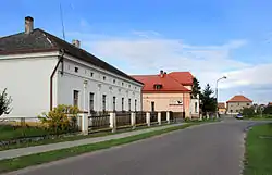 Eastern part of Hořátev | |
 Flag  Coat of arms | |
 Hořátev Location in the Czech Republic | |
| Coordinates: 50°8′59″N 15°2′24″E / 50.14972°N 15.04000°E | |
| Country | |
| Region | Central Bohemian |
| District | Nymburk |
| First mentioned | 1384 |
| Area | |
| • Total | 7.15 km2 (2.76 sq mi) |
| Elevation | 186 m (610 ft) |
| Population (2023-01-01)[1] | |
| • Total | 802 |
| • Density | 110/km2 (290/sq mi) |
| Time zone | UTC+1 (CET) |
| • Summer (DST) | UTC+2 (CEST) |
| Postal code | 289 13 |
| Website | www |
Hořátev is a municipality and village in Nymburk District in the Central Bohemian Region of the Czech Republic. It has about 800 inhabitants.
History
The first written mention of Hořátev is from 1384.[2]
References
- ↑ "Population of Municipalities – 1 January 2023". Czech Statistical Office. 2023-05-23.
- ↑ "Obec Hořátev" (in Czech). Obec Hořátev. Retrieved 2022-08-23.
Wikimedia Commons has media related to Hořátev.
This article is issued from Wikipedia. The text is licensed under Creative Commons - Attribution - Sharealike. Additional terms may apply for the media files.