Kajaran
Քաջարան | |
|---|---|
 | |
| Coordinates: 39°09′N 46°11′E / 39.150°N 46.183°E | |
| Country | |
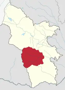
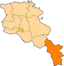
| Province | Syunik |
| Formed | 9 June 2017 |
| Administrative centre | Kajaran |
| Government | |
| • Mayor | Manvel Paramazyan |
| Population (2011 census) | |
| • Total | 9,134 |
| Time zone | AMT (UTC+04) |
| Postal code | 3201–3519 |
| ISO 3166 code | AM-SU |
| FIPS 10-4 | AM08 |
Kajaran Municipality, referred to as Kajaran Community (Armenian: Քաջարան Համայնք Kajaran Hamaynk), is an urban community and administrative subdivision of Syunik Province of Armenia, at the south of the country. Composed of a group of settlements, its administrative centre is the town of Kajaran.[1]
Included settlements
| Settlement | Type | Population (2011 census)[2] |
|---|---|---|
| Kajaran | Town, administrative centre | 7,163 |
| Ajabaj | Village | 28 |
| Andokavan | Village | 118 |
| Babikavan | Village | 216 |
| Dzagikavan | Village | 57 |
| Geghi | Village | 172 |
| Getishen | Village | 87 |
| Kajarants | Village | 250 |
| Katnarat | Village | 16 |
| Kavchut | Village | 88 |
| Lernadzor | Village | 866 |
| Nor Astghaberd | Village | 57 |
| Pkhrut | Village | 16 |
| Geghavank | Abandoned village | 0 |
| Kard | Abandoned village | 0 |
| Karut | Abandoned village | 0 |
| Kitsk | Abandoned village | 0 |
| Nerkin Giratagh | Abandoned village | 0 |
| Verin Giratagh | Abandoned village | 0 |
| Verin Geghavank | Abandoned village | 0 |
| Vocheti | Abandoned village | 0 |
See also
References
This article is issued from Wikipedia. The text is licensed under Creative Commons - Attribution - Sharealike. Additional terms may apply for the media files.