Kalpakanchery
Kalpakancheri | |
|---|---|
Village | |
 Kalpakanchery | |
Location in Malappuram district, Kerala | |
| Coordinates: 10°56′17″N 75°59′13″E / 10.938°N 75.987°E | |
| Country | |
| State | Kerala |
| District | Malappuram |
| Panchayat formation | 10 October 1940[1] |
| Government | |
| • Type | Grama Panchayat |
| • Body | Kalpakanchery Grama Panchayat |
| • President | K. P. Vahida |
| • Vice president | A. Abdul Basheer |
| Area | |
| • Total | 16.25 km2 (6.27 sq mi) |
| Population (2011)[2] | |
| • Total | 33,721 |
| • Density | 2,075/km2 (5,370/sq mi) |
| Languages | |
| • Official | Malayalam |
| 2011 Census | |
| • Sex ratio (2011) | 1191 ♀/1000♂[3] |
| • Literacy (2011) | 94.37%[4] |
| Time zone | UTC+5:30 (IST) |
| PIN | 676551, 676510 |
| Telephone code | 0494 |
| Vehicle registration | KL-55 |
| Nearest towns | |
| Niyamasabha constituency | Tirur |
| Block Panchayat | Kuttippuram |
| Website | www |
Kalpakanchery is a revenue village and a Gram Panchayat in Tirur Taluk, Malappuram district, Kerala, India. The village is located 21 kilometres (13 mi) south-west to the city of Malappuram.
Kadungathukundu, Puthanathani, Kurukathani, and Randathani are four major towns around Kalpakanchery. The National Highway 66 passes through the village. The village is a centre of academic institutions and other offices. There are several educational institutions, healthcare institutions, two industrial training centres, Kalpakanchery police station, Bafakhy Yatheem Khana (orphanage), post office, Kalpakanchery Sub-registrar Office, and Kalpakanchery Panchayat Office in the town. The village had a weekly market on Wednesdays known as Melangadi Chantha. The weekly market was held at present-day Melangadi, between Puthanathani and Kadungathukundu. The municipal towns of Tirur, Kottakkal, and Valanchery are located around 8 or 9 kilometres (5.0 or 5.6 mi) away from here.
Etymology
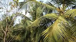
The name Kalpakanchery is believed to evolve from a combination of two Malayalam words, Kalpakam (Coconut tree) and Chery (Street), which means the street of coconut trees.[1]
Demography
As of the 2011 India census, Kalpakanchery had a population of 33,721 with 15,391 males and 18,330 females.[5] The literacy rate of the village in 2011 was 94.37%.[4] Malayalam is the most spoken language.
Education
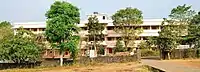
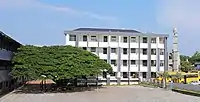
As of 2011 census, the village contains 2 pre-primary schools, 13 primary schools, 5 middle schools, 3 secondary schools, 3 senior secondary schools, 3 vocational training schools, a special school for disabled, and one more school.[6] GVHSS Kalpakanchery, established in 1958, is one of the oldest secondary schools in the area. Educational institutions in the village include:
| Name | Type | Sector |
|---|---|---|
| BYKAS College for Women, Kalpakanchery[7] | Arts&Science College | Private |
| Bafakhy ITI college, Kadungathukundu[8] | Industrial Training Institute | Private |
| Amina ITI college, Kadungathukundu[9] | Industrial Training Institute | Private |
| BYK B.Ed. Training College, Kadungathukundu[10] | Professional College | Private |
| GVHSS, Kalpakanchery | Higher Secondary School | Govt. |
| MSMHSS, Kallingalparamba | Higher Secondary School | Aided |
| BYKRHS, Kadungathukundu | High school | Private |
| GUPS, Randathani | Primary school | Govt. |
| Rahmani Primary School, Randathani | Primary school | Private |
| Najath Public School, Randathani | Primary school | Private |
| GMLPS, Paleth | Primary school | Govt. |
| GMLPS, Parapuram | Primary school | Govt. |
| GMPLS, Paravannur | Primary school | Govt. |
| AMLPS, Paravannur | Primary school | Aided |
| GMLPS, Ayirani | Primary school | Govt. |
| AMLPS, Thozhanur west | Primary school | Aided |
| AMLPS, Thozhanur east | Primary school | Aided |
| GLPS, Kalpakanchery | Primary school | Govt. |
| GMLPS, Manjachola | Primary school | Govt. |
| GMLPS, Kananchery | Primary school | Govt. |
Health
As of 2011 census, there is a Primary health centre, 3 primary health subcentres, a maternity and child welfare centre, 2 hospital alternative medicines, a dispensary, 2 veterinary hospitals, a family welfare centre, 2 charitable private hospitals, and 12 medicinal shops in the village.[6]
A government Ayurvedic hospital and a government veterinary dispensary functions at Thozhanur near to Randathani.
Civic administration
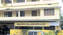
The region is administered by the Kalpakanchery Grama Panchayat. It is composed of 19 wards:[11]
Kalpakanchery is a part of Kuttippuram Block Panchayat and Tirur (State Assembly constituency).
| Ward | Name |
|---|---|
| 1 | Parapuram |
| 2 | Variyath |
| 3 | Randathani |
| 4 | Kizhakepuram |
| 5 | Tharalad |
| 6 | Manjachola |
| 7 | Kallingal |
| 8 | Paravannur Chola |
| 9 | Padathepeedika |
| 10 | Paravannur |
| 11 | Ayirani |
| 12 | Kadungathukundu |
| 13 | Kalpakanchery |
| 14 | Thottayi |
| 15 | Kananchery |
| 16 | Paleth |
| 17 | Varambingal |
| 18 | Kallingalparamba |
| 19 | Kundamchina |
Law and Order
Kalpakanchery police station has jurisdiction over seven villages namely Kalpakanchery, Valavannur, Ponmundam, Cheriyamundam, Perumanna-Klari, Athavanad, and Tirunavaya. The station was established in 1919. It comes under Tirur court.[12]
Connectivity
- Railway Station: The Tirur railway station is just 10 kilometres (6.2 mi) away from the town. Almost every train stops here.
- Road: Kalpakanchery is well connected to the other cities by road, National Highway-66 passes through the town. There are regular buses plying to other cities including Malappuram, Kozhikode, Kochi, Thrissur, and Coimbatore. There are a few private buses offering over night journeys to Bangalore, Trivandrum, and Coimbatore.
- Nearest Airport: The Karipur International Airport is approximately 30 kilometres (19 mi) away.
Notable people
- Azad Moopen
- Odayappurath Chekkutty
See also
References
- 1 2 "History of Kalpakanchery". lsgkerala.in. Retrieved 15 July 2020.
- 1 2 Directorate of Census Operations, Kerala. District Census Handbook, Malappuram (PDF). Thiruvananthapuram: Directorate of Census Operations, Kerala. p. 172. Retrieved 14 July 2020.
- ↑ Directorate of Census Operations, Kerala. District Census Handbook, Malappuram (PDF). Thiruvananthapuram: Directorate of Census Operations, Kerala. p. 350. Retrieved 14 July 2020.
- 1 2 Directorate of Census Operations, Kerala. District Census Handbook, Malappuram (PDF). Thiruvananthapuram: Directorate of Census Operations, Kerala. p. 351. Retrieved 14 July 2020.
- ↑ "2011 Census India, Malappuram District" (PDF). censusindia.gov.in.
- 1 2 Directorate of Census Operations, Kerala. District Census Handbook, Malappuram (PART-A) (PDF). Trivandrum: Directorate of Census Operations, Kerala. pp. 168–169. Retrieved 14 July 2020.
- ↑ "BYKAS College for Women, Kalpakanchery".
- ↑ "Bafakhy ITI college, Kadungathukundu".
- ↑ "Amina ITI college, Kadungathukundu".
- ↑ "BYK B.Ed. Training College, Kadungathukundu".
- ↑ "Wards in Kalpakanchery". lsgkerala.gov.in.
- ↑ "Jurisdiction of Kalpakanchery Police Station". malappuram.keralapolice.gov.in.
External links
Places adjacent to Kalpakanchery | ||||||||||||||||
|---|---|---|---|---|---|---|---|---|---|---|---|---|---|---|---|---|
| ||||||||||||||||