Karakiya | |
|---|---|
District | |
| Qaraqiia Audany | |
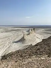 A natural rock formation in Karakiya District | |
 Seal | |
 | |
| Country | Kazakhstan |
| Region | Mangystau Region |
| Administrative center | Kuryk |
| Government | |
| • Akim | Simbat Toretayev[1] |
| Population (2013)[2] | |
| • Total | 32,304 |
| Time zone | UTC+5 (West) |
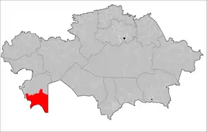
Karakiya District (Kazakh: Қарақия ауданы, romanized: Qaraqiia audany, قاراقئيا اۋدانى) is a district of Mangystau Region in south-western Kazakhstan. The administrative center of the district is the selo of Kuryk.[3] Population: 32,304 (2013 estimate);[2] 29,579 (2009 Census results);[4] 23,437 (1999 Census results).[4]
References
- ↑ "Сымбат Торетаев назначен аким Каракиянского района Мангистауской области". wwww.inform.kz (in Russian). 2023-05-19.
- 1 2 "Население Республики Казахстан" (in Russian). Департамент социальной и демографической статистики. Retrieved 27 December 2013.
- ↑ "www.geonames.de Subdivisions of Kazakhstan in local languages". Archived from the original on 2016-03-03. Retrieved 2008-04-21.
- 1 2 "Население Республики Казахстан" [Population of the Republic of Kazakhstan] (in Russian). Департамент социальной и демографической статистики. Retrieved 8 December 2013.
Capital: Aktau | ||
| Districts | 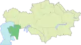 | |
| Major cities | ||
This article is issued from Wikipedia. The text is licensed under Creative Commons - Attribution - Sharealike. Additional terms may apply for the media files.