Katarraktis
Καταρράκτης | |
|---|---|
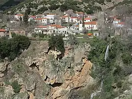 Katarraktis village view. | |
 Katarraktis | |
| Coordinates: 38°6′N 21°50′E / 38.100°N 21.833°E | |
| Country | Greece |
| Administrative region | West Greece |
| Regional unit | Achaea |
| Municipality | Erymanthos |
| Municipal unit | Farres |
| Highest elevation | 615 m (2,018 ft) |
| Lowest elevation | 565 m (1,854 ft) |
| Population (2011)[1] | |
| • Rural | 93 |
| Time zone | UTC+2 (EET) |
| • Summer (DST) | UTC+3 (EEST) |
| Postal code | 250 08 |
| Vehicle registration | AX |
Katarraktis (Greek: Καταρράκτης, meaning "waterfall") (before 1928: Lopesi, in Greek: Λόπεσι[2]) is a mountain village in the municipal unit of Farres in the municipality of Erymanthos in Achaea, Greece. It is 5 km east of Chalandritsa and 20 km southeast of Patras. In 2011 Katarraktis had a population of 93. The village is situated near a 110 meters high waterfall, hence the name of the village. Relics from the Mycenean period can be found in the vicinity.
Population
| Year | Population |
|---|---|
| 1981 | 144 |
| 1991 | 193 |
| 2001 | 101 |
| 2011 | 93 |
See also
References
- ↑ "Απογραφή Πληθυσμού - Κατοικιών 2011. ΜΟΝΙΜΟΣ Πληθυσμός" (in Greek). Hellenic Statistical Authority.
- ↑ Name changes of settlements in Greece
External links
 Media related to Katarraktis Achaias at Wikimedia Commons
- Katarraktis GTP Travel Pages
This article is issued from Wikipedia. The text is licensed under Creative Commons - Attribution - Sharealike. Additional terms may apply for the media files.