| Kemano River | |
|---|---|
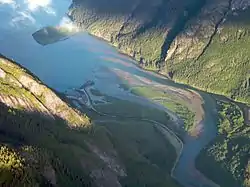 Mouth of the Kemano River | |
 Mouth of Kemano River | |
| Location | |
| Country | Canada |
| Province | British Columbia |
| District | Range 4 Coast Land District |
| Physical characteristics | |
| Source | Kitimat Ranges |
| • location | Coast Mountains |
| Mouth | Kemano Bay |
• location | Gardner Canal |
• coordinates | 53°28′16″N 128°8′12″W / 53.47111°N 128.13667°W[1] |
• elevation | 0 m (0 ft)[2] |
The Kemano River is a river in the Kitimat Ranges of the Coast Mountains in British Columbia, Canada. It flows into Kemano Bay on the Gardner Canal near the Kemano powerhouse and former townsite.[1]
See also
References
- 1 2 "Kemano River". BC Geographical Names.
- ↑ Elevation derived from ASTER Global Digital Elevation Model, using GeoLocator, BCGNIS coordinates, and topographic maps.
This article is issued from Wikipedia. The text is licensed under Creative Commons - Attribution - Sharealike. Additional terms may apply for the media files.