Keramoti
Κεραμωτή | |
|---|---|
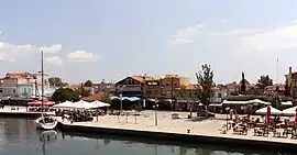 Quay street in Keramoti | |
 Keramoti Location within the regional unit 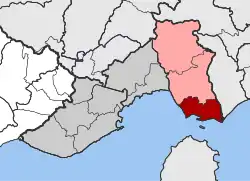 | |
| Coordinates: 40°52′N 24°42′E / 40.867°N 24.700°E | |
| Country | Greece |
| Administrative region | East Macedonia and Thrace |
| Regional unit | Kavala |
| Municipality | Nestos |
| • Municipal unit | 115.1 km2 (44.4 sq mi) |
| Population (2011)[1] | |
| • Municipal unit | 5,115 |
| • Municipal unit density | 44/km2 (120/sq mi) |
| Community | |
| • Population | 2,056 (2011) |
| Time zone | UTC+2 (EET) |
| • Summer (DST) | UTC+3 (EEST) |
| Vehicle registration | ΚΒ |
Keramoti (Greek: Κεραμωτή) is a town and a former municipality in the Kavala regional unit, East Macedonia and Thrace, Greece.[2] Since the 2011 local government reform it is part of the municipality Nestos, of which it is a municipal unit.[3] The municipal unit has an area of 115.095 km2.[4] As of the 2011 census, the municipal unit had a population of 5,115, and the town had a population of 1,438.[1] Originated as a small fisherman's village of Greek immigrants from Asia Minor, today Keramoti is a picturesque little sea resort with a sandy beach, several small hotels and a lot of vacation rentals.
Gallery
 View on Keramoti on board the ferry to Thassos
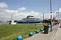 Keramoti Ferry pier
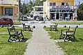 View of Keramoti
References
Wikimedia Commons has media related to Keramoti (Nestos).
- 1 2 3 "Απογραφή Πληθυσμού - Κατοικιών 2011. ΜΟΝΙΜΟΣ Πληθυσμός" (in Greek). Hellenic Statistical Authority.
- ↑ Keramoti at GEOnet Names Server
- ↑ "ΦΕΚ A 87/2010, Kallikratis reform law text" (in Greek). Government Gazette.
- ↑ "Population & housing census 2001 (incl. area and average elevation)" (PDF) (in Greek). National Statistical Service of Greece. Archived from the original (PDF) on 2015-09-21.
This article is issued from Wikipedia. The text is licensed under Creative Commons - Attribution - Sharealike. Additional terms may apply for the media files.