Kettenkamp | |
|---|---|
 Flag  Coat of arms | |
Location of Kettenkamp within Osnabrück district 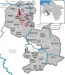 | |
 Kettenkamp 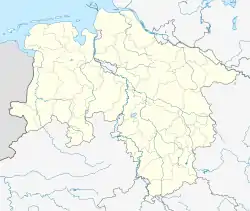 Kettenkamp | |
| Coordinates: 52°9′N 8°9′E / 52.150°N 8.150°E | |
| Country | Germany |
| State | Lower Saxony |
| District | Osnabrück |
| Subdivisions | 8 |
| Government | |
| • Mayor | Reinhard Wilke |
| Area | |
| • Total | 52.6 km2 (20.3 sq mi) |
| Elevation | 198 m (650 ft) |
| Population (2021-12-31)[1] | |
| • Total | 10,480 |
| • Density | 200/km2 (520/sq mi) |
| Time zone | UTC+01:00 (CET) |
| • Summer (DST) | UTC+02:00 (CEST) |
| Postal codes | 49577 |
| Dialling codes | 05436 |
| Vehicle registration | OS |
| Website | www.kettenkamp.de |
Kettenkamp is a municipality in the district of Osnabrück, in Lower Saxony, Germany.
References
This article is issued from Wikipedia. The text is licensed under Creative Commons - Attribution - Sharealike. Additional terms may apply for the media files.