Kirchberg-Thening | |
|---|---|
 | |
 Coat of arms | |
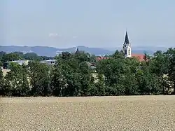
 Kirchberg-Thening Location within Austria | |
| Coordinates: 48°15′53″N 14°9′34″E / 48.26472°N 14.15944°E | |
| Country | Austria |
| State | Upper Austria |
| District | Linz-Land |
| Government | |
| • Mayor | Josef Berger (SPÖ) |
| Area | |
| • Total | 15.9 km2 (6.1 sq mi) |
| Elevation | 322 m (1,056 ft) |
| Population (2018-01-01)[2] | |
| • Total | 2,364 |
| • Density | 150/km2 (390/sq mi) |
| Time zone | UTC+1 (CET) |
| • Summer (DST) | UTC+2 (CEST) |
| Postal code | 4062 |
| Area code | 07221 |
| Vehicle registration | LL |
| Website | www.kirchberg-thening.ooe.gv.at |
Kirchberg-Thening is a municipality in the district Linz-Land in the Austrian state of Upper Austria.
Population
| Year | Pop. | ±% |
|---|---|---|
| 1869 | 1,301 | — |
| 1880 | 1,286 | −1.2% |
| 1890 | 1,277 | −0.7% |
| 1900 | 1,355 | +6.1% |
| 1910 | 1,376 | +1.5% |
| 1923 | 1,541 | +12.0% |
| 1934 | 1,443 | −6.4% |
| 1939 | 1,503 | +4.2% |
| 1951 | 1,763 | +17.3% |
| 1961 | 1,617 | −8.3% |
| 1971 | 1,803 | +11.5% |
| 1981 | 1,872 | +3.8% |
| 1991 | 1,955 | +4.4% |
| 2001 | 2,130 | +9.0% |
| 2011 | 2,298 | +7.9% |
References
- ↑ "Dauersiedlungsraum der Gemeinden Politischen Bezirke und Bundesländer - Gebietsstand 1.1.2018". Statistics Austria. Retrieved 10 March 2019.
- ↑ "Einwohnerzahl 1.1.2018 nach Gemeinden mit Status, Gebietsstand 1.1.2018". Statistics Austria. Retrieved 9 March 2019.
Wikimedia Commons has media related to Kirchberg-Thening.
This article is issued from Wikipedia. The text is licensed under Creative Commons - Attribution - Sharealike. Additional terms may apply for the media files.