Kittredge, Colorado | |
|---|---|
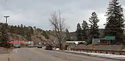 Kittredge in 2014 | |
 Location of the Kittredge CDP in Jefferson County, Colorado. | |
 Kittredge Location of the Kittredge CDP in the United States. | |
| Coordinates: 39°39′33″N 105°18′16″W / 39.6592970°N 105.3045181°W[1] | |
| Country | |
| State | |
| County | Jefferson County |
| Government | |
| • Type | unincorporated town |
| Area | |
| • Total | 1.885 sq mi (4.881 km2) |
| • Land | 1.884 sq mi (4.880 km2) |
| • Water | 0.0005 sq mi (0.0012 km2) |
| Elevation | 7,073 ft (2,156 m) |
| Population | |
| • Total | 1,308 |
| • Density | 690/sq mi (270/km2) |
| Time zone | UTC-7 (MST) |
| • Summer (DST) | UTC-6 (MDT) |
| ZIP Code[4] | 80457 |
| Area codes | 303 & 720 |
| GNIS feature[2] | Kittredge CDP |
Kittredge is an unincorporated town, a post office, and a census-designated place (CDP) located in and governed by Jefferson County, Colorado, United States. The CDP is a part of the Denver–Aurora–Lakewood, CO Metropolitan Statistical Area. The Kittredge post office has the ZIP code 80457.[4] At the United States Census 2020, the population of the Kittredge CDP was 1,308.[3]
History
The Kittredge Post Office has been in operation since 1923.[5] C. M. Kittredge, an early postmaster, gave the community his name.[6]
Geography
Kittredge is located in the valley of Bear Creek. Colorado State Highway 74 leads east down Bear Creek Canyon 8 miles (13 km) to Morrison and southwest (upstream) 2 miles (3 km) to Evergreen.
The Kittredge CDP has an area of 1,206 acres (4.881 km2), including 0.30 acres (0.0012 km2) of water.[1]
Demographics
The United States Census Bureau initially defined the Kittredge CDP for the United States Census 2000.
| Year | Pop. | ±% |
|---|---|---|
| 2000 | 954 | — |
| 2010 | 1,304 | +36.7% |
| 2020 | 1,308 | +0.3% |
| Source: United States Census Bureau | ||
Education
Kittredge is served by the Jefferson County Public Schools.
Notable residents
Kittredge is the home of former U.S. Senator and U.S. Presidential aspirant Gary Hart.
See also
References
- 1 2 3 "State of Colorado Census Designated Places - BAS20 - Data as of January 1, 2020". United States Census Bureau. Retrieved December 18, 2020.
- 1 2 3 "U.S. Board on Geographic Names: Domestic Names". United States Geological Survey. Retrieved December 18, 2020.
- 1 2 United States Census Bureau. "Kittredge CDP, Colorado". Retrieved April 15, 2023.
- 1 2 "Look Up a ZIP Code". United States Postal Service. Retrieved December 18, 2020.
- ↑ "Post offices". Jim Forte Postal History. Retrieved June 29, 2016.
- ↑ Dawson, John Frank. Place names in Colorado: why 700 communities were so named, 150 of Spanish or Indian origin. Denver, CO: The J. Frank Dawson Publishing Co. p. 29.
External links
- Kittredge @ Colorado.com
- Kittredge @ UncoverColorado.com
- Jefferson County website
- Jeffco Public Schools
Municipalities and communities of Jefferson County, Colorado, United States | ||
|---|---|---|
| Cities | 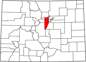 Map of Colorado highlighting Jefferson County | |
| Towns | ||
| CDPs | ||
| Unincorporated communities | ||
| Ghost towns | ||
| Footnotes | ‡This populated place also has portions in an adjacent county or counties | |