| Kizu River | |
|---|---|
 | |
| Native name | 木津川 (Japanese) |
| Location | |
| Country | Japan |
| Region | Kansai |
| Cities and towns | Iga, Kizugawa, Kyoto, Sakata |
| Physical characteristics | |
| Source | Aoyamagōgen |
| • location | Iga, Mie |
| • coordinates | 34°53′6″N 135°40′54″E / 34.88500°N 135.68167°E |
| Mouth | Yodo River |
• location | Yawata, Kyoto |
• coordinates | 34°42′29″N 136°15′57″E / 34.70806°N 136.26583°E |
• elevation | 0 m (0 ft) |
| Length | 99 km (62 mi)[1] |
| Basin size | 1,596 km2 (616 sq mi)[1] |
| Basin features | |
| River system | Yodo river basin |
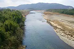
The Kizu River (木津川, Kizu-gawa) is a river that crosses the prefectures of Kyoto and Mie in Japan, a tributary of the Yodo River. The city of Kizugawa in Kyoto prefecture is named after the river.
References
- 1 2 "木津川" (in Japanese). Ministry of Land, Infrastructure, Transport and Tourism. March 2009. Archived from the original on 13 June 2015. Retrieved 7 June 2015.
| |||||||||||||||
| |||||||||||||||
| |||||||||||||||
| |||||||||||||||
| |||||||||||||||
This article is issued from Wikipedia. The text is licensed under Creative Commons - Attribution - Sharealike. Additional terms may apply for the media files.