Kunszentmiklós | |
|---|---|
 | |
 Flag  Coat of arms | |
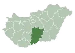
 Kunszentmiklós Location of Kunszentmiklós | |
| Coordinates: 47°01′35″N 19°07′22″E / 47.02641°N 19.12278°E | |
| Country | |
| County | Bács-Kiskun |
| District | Kunszentmiklós |
| Area | |
| • Total | 172.11 km2 (66.45 sq mi) |
| Population (2008) | |
| • Total | 8,793 |
| • Density | 52.45/km2 (135.8/sq mi) |
| Time zone | UTC+1 (CET) |
| • Summer (DST) | UTC+2 (CEST) |
| Postal code | 6090 |
| Area code | (+36) 76 |
| Website | www |
Kunszentmiklós (German: Sankt Niklas) is a town in Bács-Kiskun county, Hungary. The name is derived from the Cumans (Kun in Hungarian).
Twin cities
See also
References
External links
Wikimedia Commons has media related to Kunszentmiklós.
- Official website in Hungarian
- (in Hungarian) Térkép Kalauz – Kunszentmiklós
- (in Hungarian) Video Kunszentmiklósról – indulhatunk.hu
- (in Hungarian) Kunszentmiklós.lap.hu
- (in Hungarian) Kunszentmiklós Város Tűzoltósága
| Towns (3) |
| |
|---|---|---|
| Villages (6) | ||
This article is issued from Wikipedia. The text is licensed under Creative Commons - Attribution - Sharealike. Additional terms may apply for the media files.