Template:Attached KML/LL postcode area
KML is from Wikidata
Llandudno | |
|---|---|
 LL | |
| Coordinates: 53°07′44″N 3°43′41″W / 53.129°N 3.728°W | |
| Country | United Kingdom |
| Postcode area | LL |
| Postcode area name | Llandudno |
| Post towns | 62 |
| Postcode districts | 67 |
| Postcode sectors | 150 |
| Postcodes (live) | 20,121 |
| Postcodes (total) | 24,296 |
| Statistics as at May 2020[1] | |
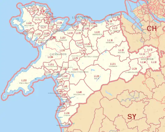
The LL postcode area, also known as the Llandudno postcode area,[2] is a group of 67 postcode districts, within 62 post towns. These cover the majority of north Wales, plus a very small part of west Wales and the English county of Shropshire. The districts start at LL11 so as to avoid confusion with Liverpool postcodes (LL1-9 would resemble L11-19).
Post towns
The post towns are:
- Aberdovey
- Abergele
- Amlwch
- Arthog
- Bala
- Bangor
- Barmouth
- Beaumaris
- Benllech
- Betws-y-Coed
- Blaenau Ffestiniog
- Bodorgan
- Brynteg
- Caernarfon
- Cemaes Bay
- Colwyn Bay
- Conwy
- Corwen
- Criccieth
- Denbigh
- Dolgellau
- Dolwyddelan
- Dulas
- Dyffryn Ardudwy
- Fairbourne
- Gaerwen
- Garndolbenmaen
- Harlech
- Holyhead
- Llanbedr
- Llanbedrgoch
- Llandudno
- Llandudno Junction
- Llanerchymedd
- Llanfairfechan
- Llanfairpwllgwyngyll
- Llangefni
- Llangollen
- Llanrwst
- Llwyngwril
- Marianglas
- Menai Bridge
- Moelfre
- Penmaenmawr
- Penrhyndeudraeth
- Pentraeth
- Penysarn
- Porthmadog
- Prestatyn
- Pwllheli
- Rhosgoch
- Rhosneigr
- Rhyl
- Ruthin
- St Asaph
- Talsarnau
- Talybont
- Towyn
- Trefriw
- Ty Croes
- Tyn-y-Gongl
- Tywyn
- Wrexham
- Y Felinheli
Coverage
The approximate coverage of the postcode districts:
Map
Template:Attached KML/LL postcode area
KML is from Wikidata
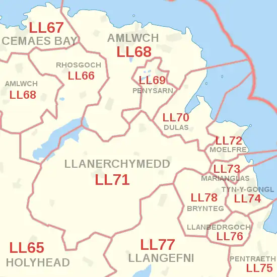
Detailed map of postcode districts and post towns in eastern Anglesey
See also
References
- ↑ "ONS Postcode Directory Version Notes" (ZIP). National Statistics Postcode Products. Office for National Statistics. May 2020. Table 2. Retrieved 19 June 2020. Coordinates from mean of unit postcode points, "Code-Point Open". OS OpenData. Ordnance Survey. February 2012. Retrieved 21 April 2012.
- ↑ Royal Mail, Address Management Guide, (2004)
- ↑ Llandegla
- ↑ Cymau
- ↑ Coedpoeth
- ↑ Caergwrle
- ↑ Llay
- ↑ Holt
- ↑ Chirk Bank
- ↑ Rhosllanerchrugog
- ↑ Bylchau; Groes; Llansannan
- ↑ LL17 0HL at SJ010707
- ↑ Kinmel Bay
- ↑ Trelawnym
- ↑ Gronant
- ↑ Trevor
- ↑ Cerrigydrudion
- ↑ Glanrafon
- ↑ Glascoed
- ↑ Abergwyngregyn
External links
This article is issued from Wikipedia. The text is licensed under Creative Commons - Attribution - Sharealike. Additional terms may apply for the media files.