Laberweinting | |
|---|---|
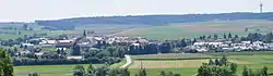 General view of Laberweinting | |
 Coat of arms | |
Location of Laberweinting within Straubing-Bogen district 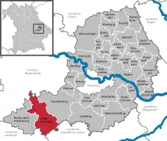 | |
 Laberweinting  Laberweinting | |
| Coordinates: 48°48′N 12°19′E / 48.800°N 12.317°E | |
| Country | Germany |
| State | Bavaria |
| Admin. region | Niederbayern |
| District | Straubing-Bogen |
| Government | |
| • Mayor (2020–26) | Johann Grau[1] (CSU) |
| Area | |
| • Total | 76.32 km2 (29.47 sq mi) |
| Elevation | 369 m (1,211 ft) |
| Population (2022-12-31)[2] | |
| • Total | 3,485 |
| • Density | 46/km2 (120/sq mi) |
| Time zone | UTC+01:00 (CET) |
| • Summer (DST) | UTC+02:00 (CEST) |
| Postal codes | 84082 |
| Dialling codes | 08772 |
| Vehicle registration | SR |
| Website | www.laberweinting.de |
Laberweinting is a municipality in the district of Straubing-Bogen in Bavaria, Germany.
Geography
The Große Laaber and the Kleine Laber, the Bayerbach and the Grafentraubach flow through the Laberweinting.
Subdivisions
The municipality Laberweinting consists of 31 villages[3]
|
|
|
|
Main sights
- Schloss Grafentraubach (built 1507)
- Church of Saint Martin (built 1679/1681)
- Church of Saint Nicholas (built 1869)
See also
References
- ↑ Liste der ersten Bürgermeister/Oberbürgermeister in kreisangehörigen Gemeinden, Bayerisches Landesamt für Statistik, 15 July 2021.
- ↑ Genesis Online-Datenbank des Bayerischen Landesamtes für Statistik Tabelle 12411-003r Fortschreibung des Bevölkerungsstandes: Gemeinden, Stichtag (Einwohnerzahlen auf Grundlage des Zensus 2011)
- ↑ Laberweinting – Bayerische Landesbibliothek Online
External links
![]() Media related to Laberweinting at Wikimedia Commons
Media related to Laberweinting at Wikimedia Commons
This article is issued from Wikipedia. The text is licensed under Creative Commons - Attribution - Sharealike. Additional terms may apply for the media files.