| Lagrange Creek Tributary to Rappahannock River | |
|---|---|
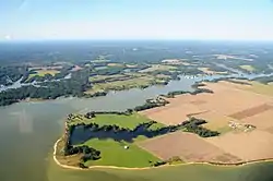 Lagrange Creek near Urbanna, on the Rappahannock River, Virginia | |
 Location of Lagrange Creek mouth  Lagrange Creek (Rappahannock River tributary) (the United States) | |
| Location | |
| Country | United States |
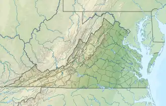
| State | Virginia |
| County | Middlesex |
| Physical characteristics | |
| Source | Briery Swamp and Wyatt Swamp divide |
| • location | about 2 miles southeast of Jamaica, Virginia |
| • coordinates | 37°41′28″N 076°41′00″W / 37.69111°N 76.68333°W[1] |
| • elevation | 70 ft (21 m)[2] |
| Mouth | Rappahannock River |
• location | Long Point, Virginia |
• coordinates | 37°40′08″N 076°35′13″W / 37.66889°N 76.58694°W[1] |
• elevation | 0 ft (0 m)[2] |
| Length | 6.51 mi (10.48 km)[3] |
| Basin size | 16.89 square miles (43.7 km2)[4] |
| Discharge | |
| • location | Rappahannock River |
| • average | 19.02 cu ft/s (0.539 m3/s) at mouth with Rappahannock River[4] |
| Basin features | |
| Progression | southeast |
| River system | Rappahannock River |
| Tributaries | |
| • left | unnamed tributaries |
| • right | South Branch Lagrange Creek |
| Waterbodies | Burch Pond |
| Bridges | Burchs Mill Road |
Lagrange Creek is a 6.51 mi (10.48 km) long 3rd order tributary to the Rappahannock River in Middlesex County, Virginia.
Variant names
According to the Geographic Names Information System, it has also been known historically as:[1]
- La Grange Creek
In colonial times it was known as[5]
- Burnham's Creek
- Sunderland Creek
Course
Lagrange Creek rises on the Briery Swamp and Wyatt Swamp divide about 2 miles southeast of Jamaica, Virginia. Lagrange Creek then flows southeast to meet the Rappahannock River at Long Point, Virginia.[2]
Watershed
Lagrange Creek drains 16.89 square miles (43.7 km2) of area, receives about 45.7 in/year of precipitation, has a topographic wetness index of 512.02 and is about 40.9% forested.[4]
Maps
.gif)
Course of Lagrange Creek (Rappahannock River tributary)
.gif)
Watershed of Lagrange Creek (Rappahannock River tributary)
See also
References
- 1 2 3 "GNIS Detail - Lagrange Creek". geonames.usgs.gov. US Geological Survey. Retrieved 12 March 2020.
- 1 2 3 "Lagrange Creek Topo Map, Middlesex County VA (Urbanna Area)". TopoZone. Locality, LLC. Retrieved 12 March 2020.
- ↑ "ArcGIS Web Application". epa.maps.arcgis.com. US EPA. Retrieved 12 March 2020.
- 1 2 3 "Lagrange Creek Watershed Report". Waters Geoviewer. US EPA. Retrieved 12 March 2020.
- ↑ Gill, Dan (February 2013). "Sunderland" (PDF). Retrieved November 6, 2021.
This article is issued from Wikipedia. The text is licensed under Creative Commons - Attribution - Sharealike. Additional terms may apply for the media files.