Lambrook, Arkansas | |
|---|---|
 Lambrook, Arkansas  Lambrook, Arkansas | |
| Coordinates: 34°20′08″N 90°58′03″W / 34.33556°N 90.96750°W | |
| Country | United States |
| State | Arkansas |
| County | Phillips |
| Elevation | 161 ft (49 m) |
| Time zone | UTC-6 (Central (CST)) |
| • Summer (DST) | UTC-5 (CDT) |
| ZIP code | 72353 |
| Area code | 870 |
| GNIS feature ID | 58044[1] |

Warrens Bridge in Lambrook
Lambrook is an unincorporated community in Phillips County, Arkansas, United States. Lambrook is located on Arkansas Highway 20, 7 miles (11 km) west-northwest of Elaine. Lambrook has a post office with ZIP code 72353.[2]
References
Municipalities and communities of Phillips County, Arkansas, United States | ||
|---|---|---|
| Cities | 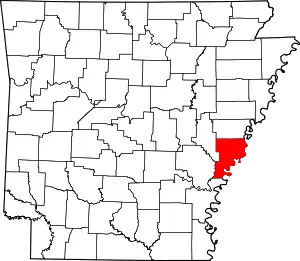 Map of Arkansas highlighting Phillips County | |
| Town | ||
| Townships |
| |
| CDPs | ||
| Other unincorporated communities | ||
This article is issued from Wikipedia. The text is licensed under Creative Commons - Attribution - Sharealike. Additional terms may apply for the media files.