Langquaid | |
|---|---|
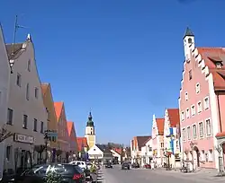 Market square with the town hall to the right | |
 Coat of arms | |
Location of Langquaid within Kelheim district 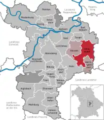 | |
 Langquaid  Langquaid | |
| Coordinates: 48°49′N 12°03′E / 48.817°N 12.050°E | |
| Country | Germany |
| State | Bavaria |
| Admin. region | Niederbayern |
| District | Kelheim |
| Municipal assoc. | Langquaid |
| Subdivisions | 8 Ortsteile |
| Government | |
| • Mayor (2020–26) | Herbert Blascheck[1] (CSU) |
| Area | |
| • Total | 56.79 km2 (21.93 sq mi) |
| Elevation | 389 m (1,276 ft) |
| Population (2022-12-31)[2] | |
| • Total | 5,929 |
| • Density | 100/km2 (270/sq mi) |
| Time zone | UTC+01:00 (CET) |
| • Summer (DST) | UTC+02:00 (CEST) |
| Postal codes | 84083–84085 |
| Dialling codes | 09452 |
| Vehicle registration | KEH |
| Website | www.langquaid.de |
Langquaid is a municipality in the district of Kelheim in Bavaria in Germany.
Ortsteile
Villages affiliated to the administration (Ortsteil) of Langquaid are
- Adlhausen
- Hellring
- Leitenhausen
- Niederleierndorf
- Oberleierndorf
- Paring
- Unterschneidhart
- Mitterschneidhart
- Oberschneidhart
References
- ↑ Liste der ersten Bürgermeister/Oberbürgermeister in kreisangehörigen Gemeinden, Bayerisches Landesamt für Statistik, 15 July 2021.
- ↑ Genesis Online-Datenbank des Bayerischen Landesamtes für Statistik Tabelle 12411-003r Fortschreibung des Bevölkerungsstandes: Gemeinden, Stichtag (Einwohnerzahlen auf Grundlage des Zensus 2011)
External links
Towns and municipalities in Kelheim (district) | ||
|---|---|---|
Coat of Arms of Kelheim district | ||
This article is issued from Wikipedia. The text is licensed under Creative Commons - Attribution - Sharealike. Additional terms may apply for the media files.