Lincent
| |
|---|---|
.jpg.webp) | |
 Coat of arms | |
Location of Lincent | |
 Lincent Location in Belgium
Location of Lincent in the province of Liège 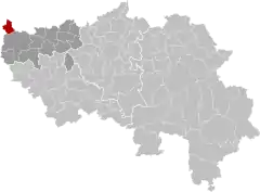 | |
| Coordinates: 50°43′N 05°02′E / 50.717°N 5.033°E | |
| Country | |
| Community | French Community |
| Region | Wallonia |
| Province | Liège |
| Arrondissement | Waremme |
| Government | |
| • Mayor | Yves Kinnard (MR) |
| • Governing party/ies | MR-CDH-Ecolo |
| Area | |
| • Total | 14.73 km2 (5.69 sq mi) |
| Population (2018-01-01)[1] | |
| • Total | 3,292 |
| • Density | 220/km2 (580/sq mi) |
| Postal codes | 4287 |
| NIS code | 64047 |
| Area codes | 019 |
| Website | www.lincent.be |
Lincent (French pronunciation: [lɛ̃sɑ̃]; Dutch: Lijsem, Dutch pronunciation: [ˈlɛi̯səm] ⓘ; Walloon: Lîssin) is a municipality of Wallonia located in the province of liège, Belgium.
On January 1, 2006, Lincent had a total population of 2,998. The total area is 14.75 km² which gives a population density of 203 inhabitants per km².
The municipality consists of the following districts: Lincent, Pellaines, and Racour.
References
- ↑ "Wettelijke Bevolking per gemeente op 1 januari 2018". Statbel. Retrieved 9 March 2019.
External links
 Media related to Lincent at Wikimedia Commons
Municipalities in the province of Liège, Wallonia | ||
|---|---|---|
| Huy | 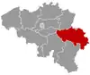 | |
| Liège | ||
| Verviers | ||
| Waremme | ||
| ||
This article is issued from Wikipedia. The text is licensed under Creative Commons - Attribution - Sharealike. Additional terms may apply for the media files.