Littleton, Kentucky | |
|---|---|
CDP | |
 Littleton, Kentucky | |
| Coordinates: 37°09′45″N 83°45′17″W / 37.16250°N 83.75472°W | |
| Country | United States |
| State | Kentucky |
| County | Clay |
| Elevation | 902 ft (275 m) |
| Time zone | UTC-5 (Eastern (EST)) |
| • Summer (DST) | UTC-4 (EDT) |
| Area code | 606 |
| GNIS feature ID | 2629640[1] |
Littleton is a Census Designated Place in Clay County, Kentucky, United States. Littleton is located on the northern border of Manchester.[2]
References
- ↑ "Littleton". Geographic Names Information System. United States Geological Survey, United States Department of the Interior.
- ↑ State Primary Road System: Clay County (PDF) (Map). Kentucky Transportation Cabinet. 2013. Retrieved February 22, 2013.
Municipalities and communities of Clay County, Kentucky, United States | ||
|---|---|---|
| City | 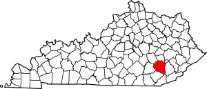 Location of Clay County, Kentucky | |
| CDPs | ||
| Other unincorporated communities | ||
| post offices (and the creeks they are on) |
| |
This article is issued from Wikipedia. The text is licensed under Creative Commons - Attribution - Sharealike. Additional terms may apply for the media files.