| Loch of Bosquoy | |
|---|---|
| Bosquoy loch | |
 Loch of Bosquoy | |
| Location | Orkney, Scotland |
| Coordinates | 59°02′52″N 3°12′47″W / 59.04778°N 3.21306°W |
| Type | freshwater loch |
| Primary outflows | Loch of Harray via a sluice |
| Catchment area | 3.25 sq mi (8.4 km2)[1] |
| Basin countries | Scotland |
| Max. length | 0.75 mi (1.21 km)[1] |
| Max. width | 0.33 mi (0.53 km)[1] |
| Surface area | 65 acres (0.26 km2)[1] |
| Average depth | 2.5 ft (0.76 m)[1] |
| Max. depth | 5 ft (1.5 m)[1] |
| Water volume | 7,000,000 cu ft (200,000 m3)[1] |
| Surface elevation | 36 ft (11 m)[1] |
| Islands | Islets of reeds[1] |
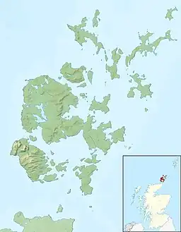
The Loch of Bosquoy is a small, shallow, rhomboid shaped loch on Mainland, Orkney, Scotland situated just off the north east corner of the Loch of Harray. The loch was surveyed[1] during 1903 by Sir John Murray and later charted [2] as part of The Bathymetrical Survey of Fresh-Water Lochs of Scotland 1897–1909.
References
- 1 2 3 4 5 6 7 8 9 10 "Bathymetrical Survey of the Fresh-Water Lochs of Scotland, 1897-1909, Lochs of Orkney". National Library of Scotland. Retrieved 3 August 2013.
- ↑ "View, Lochs of Stenness, Harray and Bosquoy - Bathymetrical Survey, 1897-1909 - National Library of Scotland". National Library of Scotland. Retrieved 29 July 2013.
This article is issued from Wikipedia. The text is licensed under Creative Commons - Attribution - Sharealike. Additional terms may apply for the media files.