Lom u Tachova | |
|---|---|
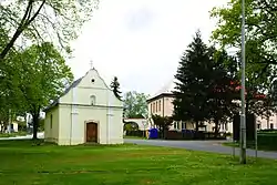 Chapel of Our Lady Queen of Peace | |
 Flag  Coat of arms | |
 Lom u Tachova Location in the Czech Republic | |
| Coordinates: 49°49′8″N 12°41′34″E / 49.81889°N 12.69278°E | |
| Country | |
| Region | Plzeň |
| District | Tachov |
| First mentioned | 1379 |
| Area | |
| • Total | 8.44 km2 (3.26 sq mi) |
| Elevation | 500 m (1,600 ft) |
| Population (2023-01-01)[1] | |
| • Total | 495 |
| • Density | 59/km2 (150/sq mi) |
| Time zone | UTC+1 (CET) |
| • Summer (DST) | UTC+2 (CEST) |
| Postal code | 347 01 |
| Website | www |
Lom u Tachova is a municipality and village in Tachov District in the Plzeň Region of the Czech Republic. It has about 500 inhabitants.
Lom u Tachova lies approximately 6 kilometres (4 mi) east of Tachov, 50 km (31 mi) west of Plzeň, and 128 km (80 mi) west of Prague.
References
Wikimedia Commons has media related to Lom u Tachova.
This article is issued from Wikipedia. The text is licensed under Creative Commons - Attribution - Sharealike. Additional terms may apply for the media files.